
| Area | Basin-wide/General |
| Topic | Timber Harvest: Percent Harvested by Garcia Calwater 1987-2001 |
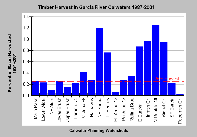
| Caption: This chart shows the percent area of Garcia Basin Calwater Planning Watersheds permitted for timber harvest plans (THPs) between 1987 and 2001 according to the California Department of Forestry, Santa Rosa office. Values are sums without subtraction for overlapping THPs so totals may be more than 100% in some cases. Basins with very high timber harvest permitting are Middle Garcia or North Gualala Mt. (125 %), North Fork Garcia (120 %), Inman Creek (97 %), and Signal Creek (95 %). Coastal basins such as Roseman Creek, Pt Arena Creek and North Fork Alder Creek have the lowest range of values, partially because there are extensive grasslands and pastures on the coastal terraces. THPs filed since 1999 may not have been cut yet. For full names of Calwaters, see the Chart Table. The threshold of 25% harvest is after the Reeves et al. (1993) finding that diversity of salmonids in Oregon coastal streams was diminished when basins were harvested over this level. See InfoLinks for more information or Map for spatial data. | |
 |
To learn more about this topic click Info Links .
To view additional information (data source, aquisition date etc.) about this page, click Metadata .
To view the table with the chart's data, click Chart Table web page.
To download the table with the chart's data, click thp_garcia_pct.dbf (size 1,885 bytes) .
| www.krisweb.com |