
| Area | South Fork Garcia |
| Topic | Sediment: Road-Related Erosion Potential Volume in SF Garcia 1998 |
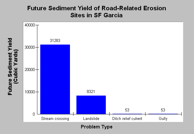
| Caption: This Chart shows future sediment yield from road-related potential erosion sites in the South Fork Garcia watershed if no restoration were to take place, based on data collected during road surveys in 1998. This chart does not include persistent surface erosion, which is a major sediment contributor. Future yield is the total potential erosion multiplied by the probability of delivery to a stream. Stream crossings were by far the largest source of future sediment yield. Most sites inventoried that showed major potential were treated. Data were provided by Trout Unlimited and Pacific Watershed Associates (1999). See InfoLinks for more information. | |
 |
To learn more about this topic click Info Links .
To view additional information (data source, aquisition date etc.) about this page, click Metadata .
To view the table with the chart's data, click Chart Table web page.
To download the table with the chart's data, click sed_road_sfgar_mrcpwatu_1998_chart.db (size 4,096 bytes) .
To view the table with the chart's source data, click Source Table web page.
To download the table with the chart's source data, click sed_road_sfgar_mrcpwatu_1998_source.db (size 167,936 bytes)
| www.krisweb.com |