
|

|
| Background | Hypotheses | Bibliography | Maps | Home |
|
|
|
| Background | Hypotheses | Bibliography | Maps | Home |
KRIS Web Background Pages: Riparian Areas
![]()
The KRIS Gualala database contains canopy cover information from habitat typing surveys provided by the California Department of Fish and Game (CA RA, In Review) and the Sotoyome Resource Conservation District. This information can be used to gauge stream health (see Habitat Typing background page). Canopy is measured with a densiometer. One problem with canopy information is that is does not indicate riparian over-story conditions, which effect microclimate and large wood recruitment potential (see Riparian Function and Protection Background page and Hypothesis #5).
 |
The
upper North Fork Gualala watershed (Billings Creek Calwater) may have naturally
high components of small diameter trees and non-forest due to bedrock geology
as shown by the USFS vegetation map at left. However, the young age of the
riparian forest in the western North Fork basin is largely a result of timber
harvest. Natural open canopy conditions in the upper basin leave the stream
open to warming but small diameter trees in the western basin also promote
warming and indicate a lack of potential large wood for recruitment into
the stream for salmonid habitat.
|
|
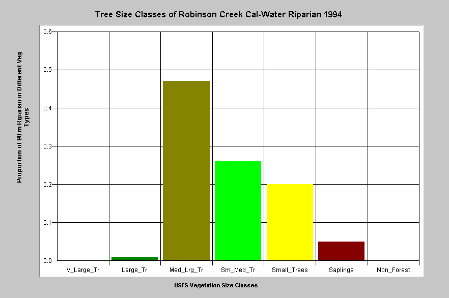
The riparian zone of the Robinson Creek Calwater in the North Fork Gualala
basin as of 1994 had more than half its riparian zone in very early seral
stage conditions (<20 " diameter) with 25% of trees less than 12".
This indicates recent timber harvest in this zone and that there is a shortage
of large trees next to the stream to supply large wood. This Calwater
includes much of the lower mainstem North Fork as well as Robinson, McGann
and Dry creeks.
|
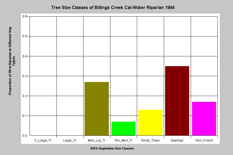 |
Vegetation and timber types of the riparian zone of the Billings Creek Calwater are displayed at left and shows high components of Non-Forest (17%) and Saplings. This is largely natural because it has large areas of grassland and oak woodlands as a result of underlying Central Belt Franciscan terrain. |
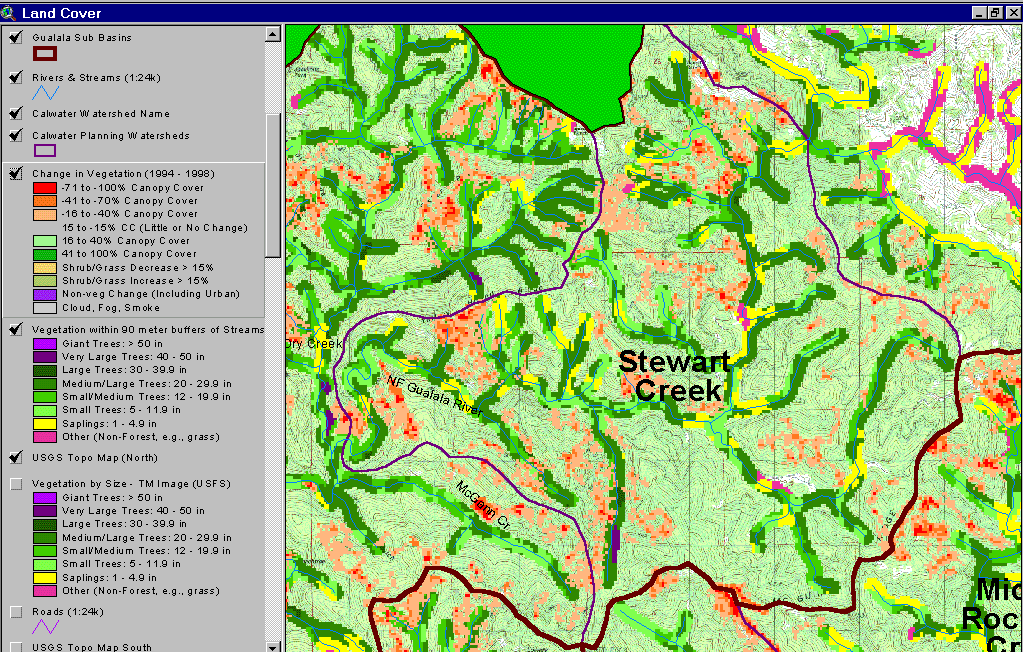 |
This image shows the Stewart Creek Calwater with a 90 meter buffer riparian zone and 1994 and 1998 change scene detection. Red (>70%) and orange (40-70%) indicate that there has been substantial timber removal within the 90-meter buffer area on both the mainstem North Fork and its tributaries, particularly Hayfield Creek (at upper right) and Lost Creek. The latter is a tributary of Dry Creek that was grouped with the Stewart Creek Calwater (at left). Also of concern are the steep inner gorge areas and headwaters harvested. The latter are Class III streams and have less protection under California Forest Practice Rules. |
 |
Clear cuts show in the photo at left of the North Fork Gualala River looking south along the San Andreas Fault. The clear cuts abut the 100-foot watercourse and lake protection zone (WLPZ). Because the USFS 90 meter riparian buffer has a one hectare resolution, tree size classes would be averaged with edge of the clear cut. Although these riparian zones afford shade, they are not sufficient to minimize airflow over streams (see Temperature Background page), and thus to fully protect cool water temperature regimes. Since redwoods may exceed 200 feet in height, if left to grow, harvests in the 100 to 200 foot band also deprive the stream of large wood. |
|
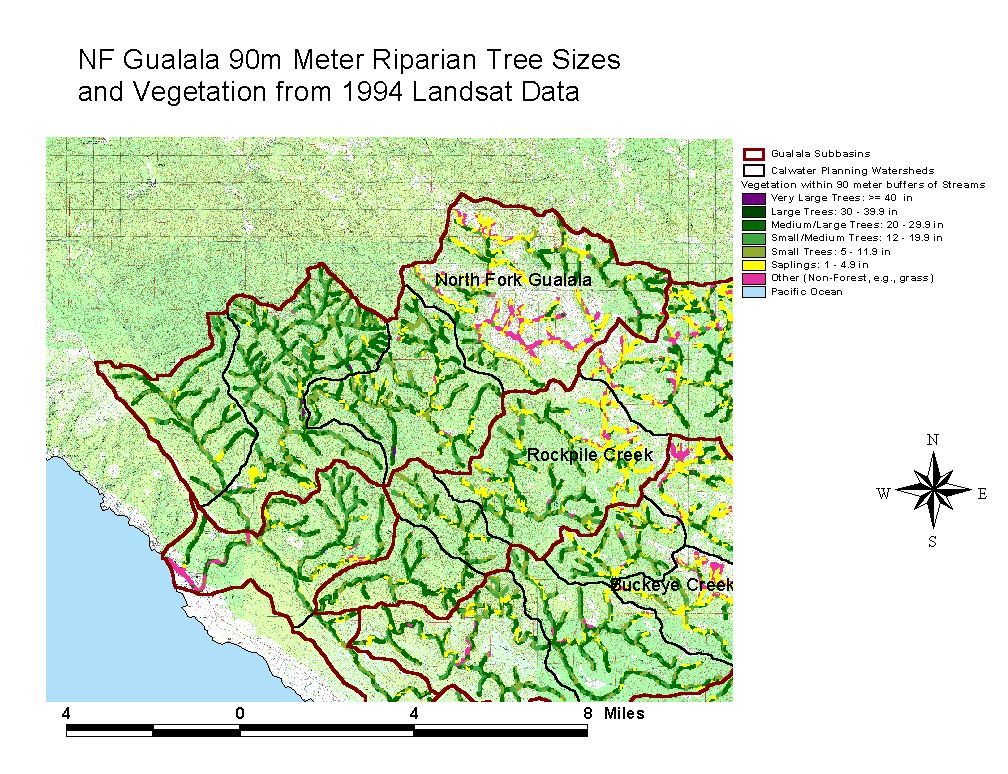
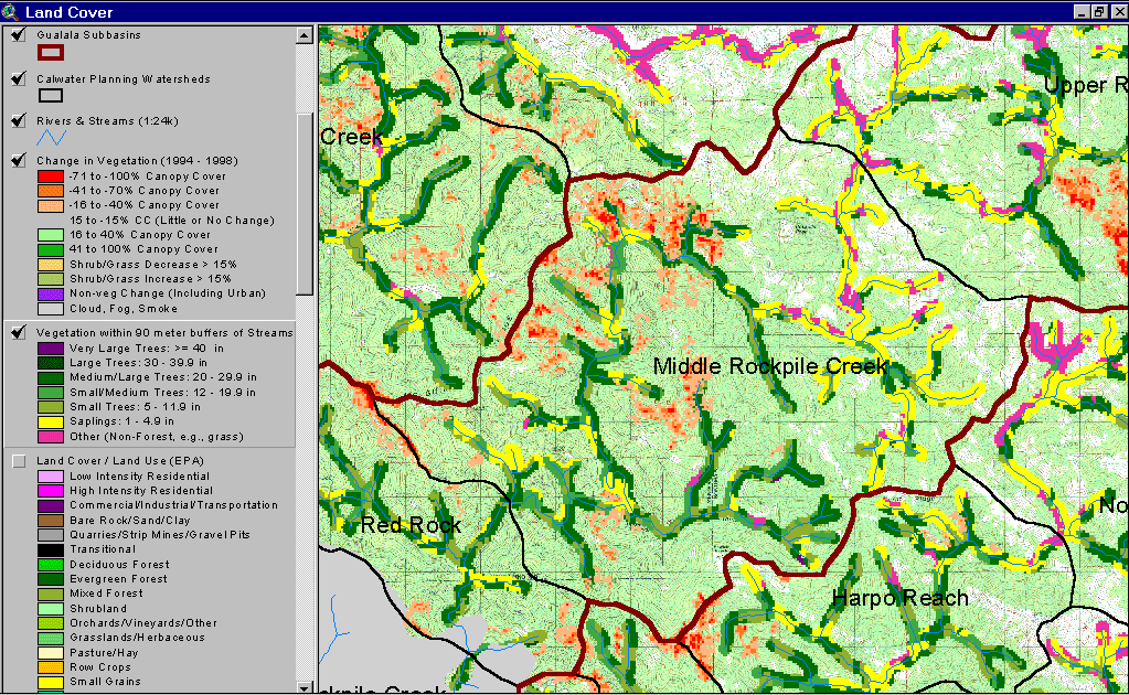
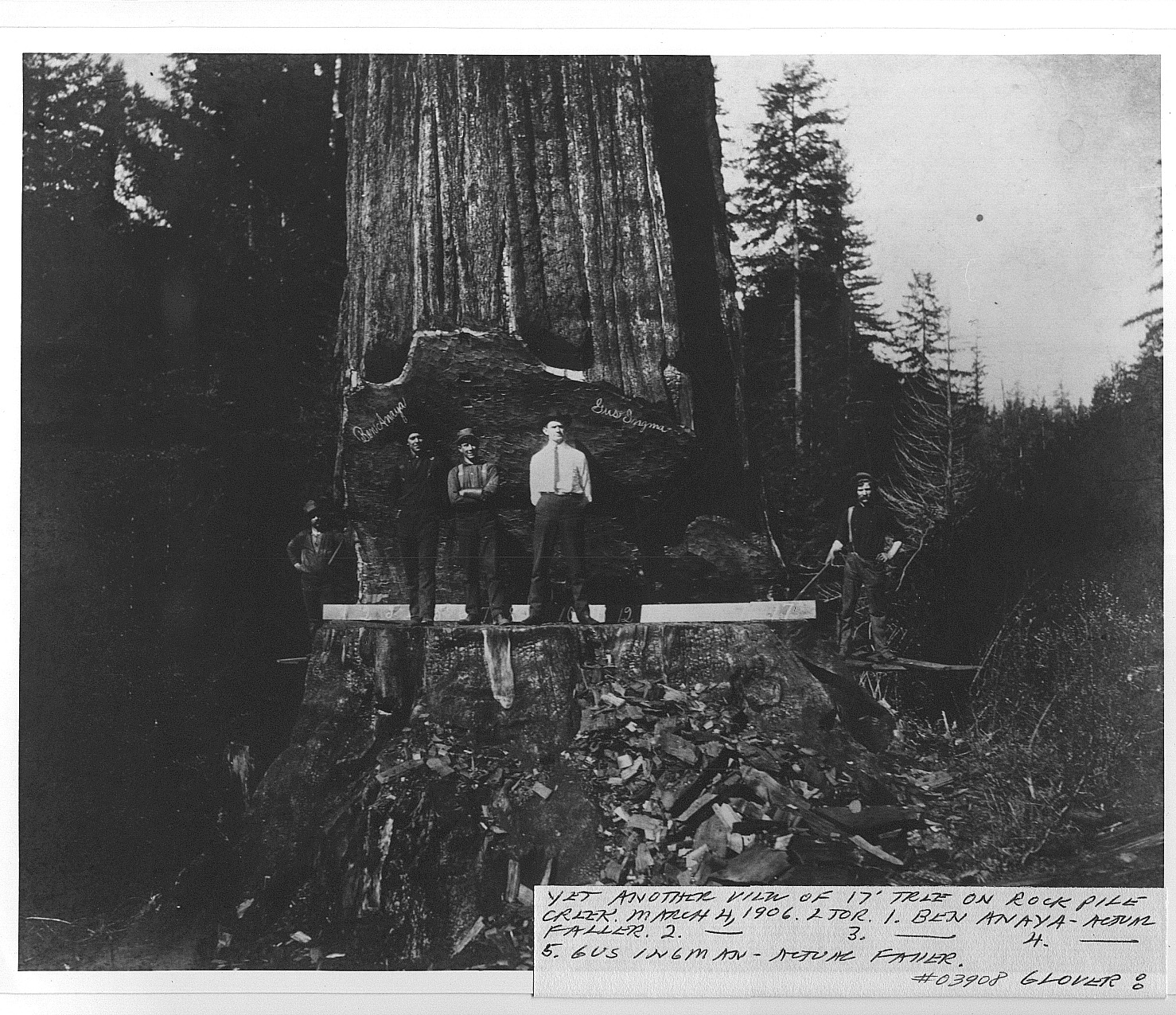
Rockpile Creek's 90 meter riparian buffer for the Middle Rockpile and Red
Rock Calwater planning watersheds are displayed at left. Natural grasslands
in eastern Rockpile Creek give rise to Non-Forest, Saplings and Small Trees.
However, the predominance of trees less than 20" in the Red Rock and
the western Middle Rockpile Calwaters are a result of very recent timber
harvest. Site potential in Rockpile Creek for conifer growth is high and
original riparian trees were over 17 feet in
diameter. Changes in the landscape between 1994 and 1998 based on Landsat
images, shows a similar pattern of riparian and inner gorge harvest, which
depletes potential large wood supply (see Hypothesis
#5).
|
|
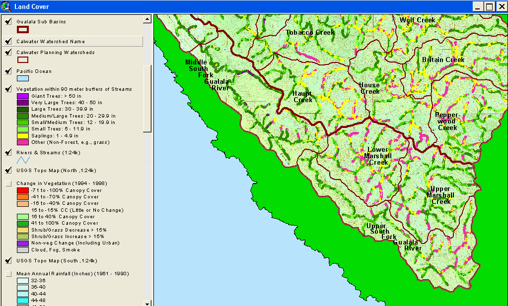
The map of the South Fork Gualala 90-meter riparian zone at left shows the
influence of the Ohlsen Ranch formation, which is associated with Non-Forest
and Saplings vegetation signatures. Very Large or Large Trees remain in
the Middle South Fork Calwater Planning Watershed because there has been
less recent active timber harvest. Consequently, this reach is important
for buffering naturally warm temperatures from upland areas and for future
large wood recruitment.
|
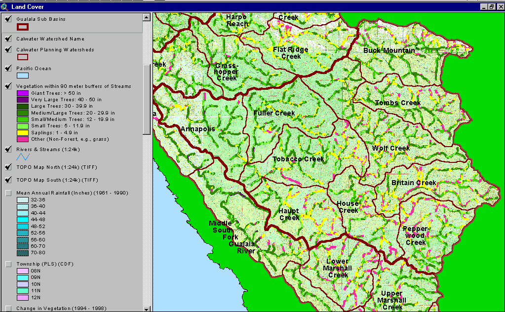 |
Vegetation stand types for the riparian zone of all Wheatfield Fork Calwater Planning Watersheds based on a 1994 Landsat image are displayed at left. Much of the riparian zones in eastern Calwaters show as Non-Forest, Saplings and Small Trees as a result of natural grasslands in mélange terrain of the Central Belt Franciscan. Annapolis, Fuller Creek, western Tobacco Creek and western Haupt Creek all have high site potential forest soils and small diameter trees in the riparian zone of these latter areas are indicative of past and recent timber harvest. |
![]()
References
California Resources Agency. In Review. Gualala River Watershed Synthesis. CA Dept. of Fish and Game, State Water Res. Control Bd., CA Dept. of Water Resources, CA Div. on Mines and Geology and CA Dept. of Forestry. Sacramento, CA. Draft released January 16, 2001.
Keithley, C. 1999. Evaluating Stream and Watershed Conditions in Northern California. Prepared for the California Department of Forestry, Fire and Resource Assessment Program. Sacramento, CA. 17 pp.
![]()
| www.krisweb.com |