Bibliography Background About KRIS
Hypothesis #5: Recent riparian timber harvest has exacerbated water temperature problems in western Gualala River sub-basins.
Support for the Hypothesis
The Forest Ecosystem Management Assessment Team (FEMAT, 1994) recommended a buffer of two site potential tree heights (or to the slope break of the inner gorge) to fully protect functional riparian conditions and promote recovery of Pacific salmon species (see Riparian Function and Protection background page). Pool and Berman (2000) noted that removal of trees in the riparian zone, even back from the stream, opened the area above the stream to warm airflow and facilitated stream warming. Bartholow (1989) compared temperature data and riparian conditions from throughout the West and found that air temperature was the dominant driver of water temperature (Figure 1). Sinokrot and Stefan (1994) created models which showed that "solar (short-wave) radiation is the most important component of the heat flux across the stream water surface, but none of the other components, i.e., long-wave radiation, evaporation and convection to the atmosphere are negligible". Chen (1991) found that the riparian zone of influence was over two site potential tree heights back into the forest and that riparian thermal and humidity buffering functions decreased substantially under one site potential tree height (Figure 2). Historical records in the Gualala Basin indicate that riparian trees were often several feet in diameter and likely taller than 200 feet (Figure 3).
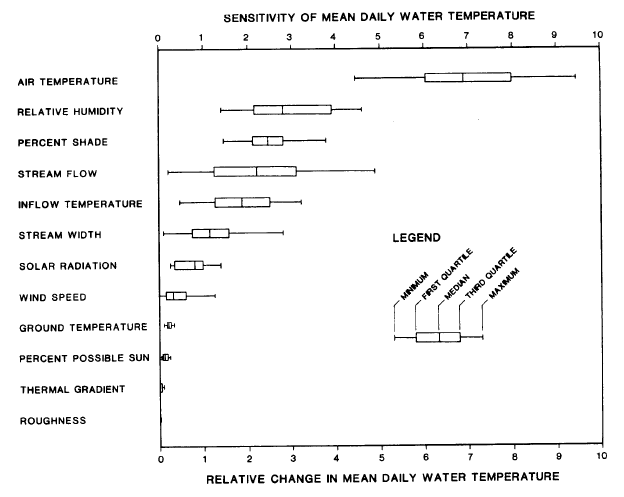 Figure 1. Bartholow (1989) found that air temperature over the stream was by far the most important driver of mean daily water temperatures, followed by relative humidity and, third by shade. The latter two have such significant overlap that they should be considered of equal importance in maintaining cool water temperatures. Protection for riparian zones under California Forest Practice Rules has emphasized maintaining shade over the stream, not maintaining a cool microclimate.
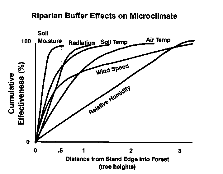 Figure 2. Chen studied riparian response to timber harvests and the results of his studies are shown at left, with percent of riparian function retained on the Y-axis and site potential tree heights on the X-axis. The chart indicates that when the riparian buffer width is less than one site potential tree height, humidity drops by two thirds and the ability to maintain cool air over the stream drops dramatically. California Forest Practice Rules maintain a 100 foot buffer on Class I watercourses, which is one half or less of site potential in a redwood forest (Spence et al., 1996). Selective harvest of large conifers can take place even within this zone. This graphic is from the FEMAT (1993).
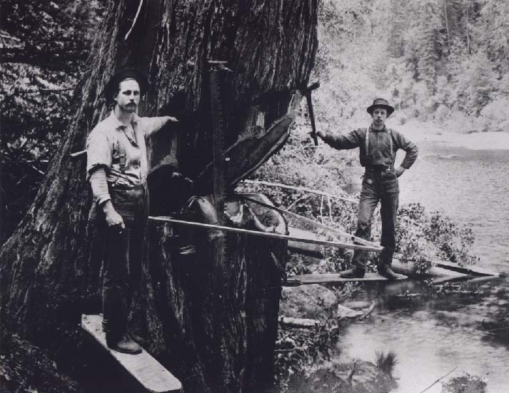 Figure 3. This historic photo shows old-time residents of the Gualala falling timber near one of the river's tributaries. The basal diameter of the tree appears to be four to six feet. Redwood trees with this diameter are often well over 200 feet tall. Old growth forests encroaching on the stream would have not only provided shade, but also a substantially cooler and more humid microclimate over the stream. Dense groves of these very tall trees probably were able to keep even larger order streams buffered from warm airflow from upland areas. Use of photo allowed by Alice Fiscus and the Fiscus family. Provided for use in KRIS by Ken Spacek.
Water temperature data are available from 1994 to 2001 for most of the western Gualala River basin. Data were collected by Gualala Redwoods, Inc. and the Gualala River Watershed Council. The North Coast Regional Water Quality Control Board described temperature patterns in the North Fork Gualala basin at various locations (California Resources Agency, In review). Lewis et al. (2000) noted that streams tend to cool as they enter the zone of marine influence and summer fog. The North Fork Gualala is expected to be warm coming from the east off mélange terrain of the Central Belt Franciscan, where canopy conditions may be naturally more open. It cools, as expected, from 72o Fahrenheit at the upstream boundary of GRI property to 65o F below Robinson Creek (Figures 4). It then warms to 67o F near Peach Tree Flat, less than two miles downstream. This is contrary to what might be expected, since this reach of the North Fork is approaching the coast and is fed by small, cool, coastal tributaries. Warming is therefore caused by some local influence between Robinson Creek and Peach Tree Flat.
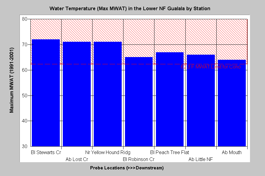 Figure 4. This chart shows the maximum floating weekly average water temperature (MWAT) at various locations in the North Fork Gualala from 1994-2001. The North Fork cools from 720 F to 650 F as it moves west off mélange terrain to below Robinson Creek. It then warms again at Peach Tree Flat before cooling again at the Little North Fork and at the convergence with the South Fork Gualala. The reference indicating the 62.3o F tolerance limit for coho is from Welsh et al. (2001) and shows that all reaches were too warm for coho, at least in some years.
The U.S. Forest Service Spatial Analysis Lab in Sacramento has produced vegetation and tree diameter size spatial data for the all of Northern California, including the Gualala basin, from 1994 Landsat imagery (see Vegetation Types background page). Data resolution is one hectare. The KRIS project selected a riparian zone distance of 90 meters (292') for analysis of tree size and vegetation type in areas likely to affect Gualala River water temperature, although two site potential tree heights for redwoods is more equivalent to 400 feet (Spence et al., 1996). While individual large trees may be missed by Landsat because of resolution, the tree diameters clearly show very early seral stage conditions, which allow open air flow over the stream (Figure 5-6).
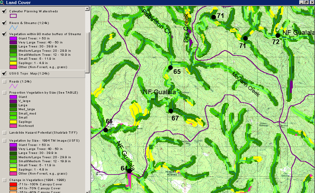 Figure 5. This map of the lower North Fork Gualala basin shows the vegetation and tree size according to a 1994 Landsat image. The North Fork between Robinson to below Peach Tree Flat has a substantial component of trees less than 12 inches in diameter, as shown in the light green and yellow colors. The maximum floating weekly average (MWAT) temperatures from Figure 4 are also displayed on the map. The USGS topographic map back drop shows that in less than two miles the stream warms from an MWAT of 65o to 67o F, likely in response to open canopy conditions.
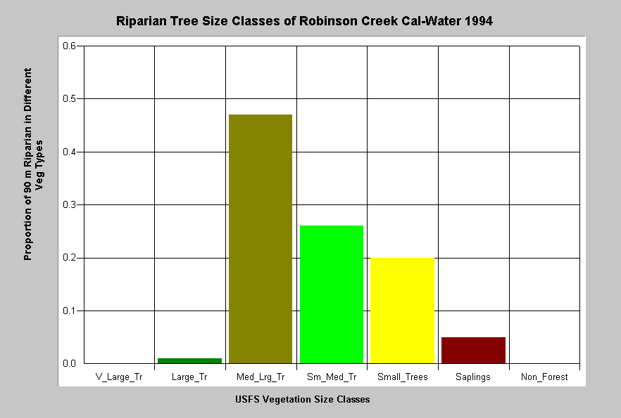 Figure 6. This chart shows the average tree diameters within the 90 meter riparian zone of the Robinson Creek Calwater Planning Watershed, which includes the North Fork Gualala reach shown in Figure 5. These data indicate that in 1994 only 47% of the riparian in the Calwater was comprised of trees over 20-29.9" in diameter (Medium-Large Trees). All other trees were smaller, with Small-Medium Trees (12-19.9" diameter) making up 26% of the riparian buffer, Small Trees (5-11.9" diameter) comprising 20% and Saplings (< 5" diameter) 6%. These conditions are indicative of active logging since 1985 (Figure 7) and would be conducive to open airflow over the stream..
The California Department of Forestry provided data on timber harvests permitted between 1991 and 2001. The data indicate that substantial timber harvest has taken place in the riparian zones of the western Gualala basin. CDF timber harvest data for the lower North Fork Gualala River riparian zone shows active logging since 1991 (Figure 7).
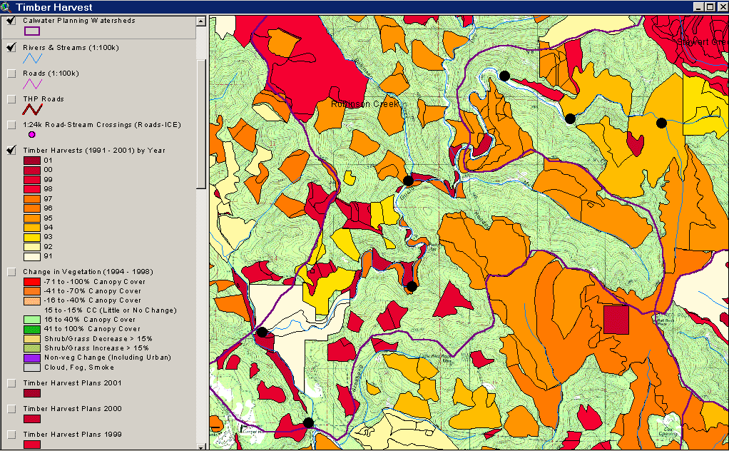 Figure 7. This image shows active timber harvest in the lower North Fork Gualala Riparian Zone since 1991. The black spots indicate locations of water temperature monitoring stations on the mainstem North Fork Gualala River which are also displayed in Figure 5. The mouth of the North Fork is at the lower left and the upper most site, at right, is the eastern boundary of GRI.
California Department of Fish and Game's 2001 habitat typing (California Resources Agency, 2001) showed extensive reaches of western Gualala basin streams with either open canopy or shade provided by deciduous trees (Figure 8). In Rockpile, Buckeye and the North Fork Gualala, riparian zones would be dominated by conifers if logging were not occurring. Aerial photos from recent periods also show narrow buffers that allow increased warm airflow (Figure 9).
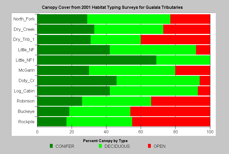 Figure 8. CDFG 2001 habitat typing showed that both large and small tributaries of the western Gualala basins had substantial reaches of open canopy, where streams would be susceptible to warming. The high deciduous component is also associated with a more open canopy and airflow over the stream. While the mainstems of Rockpile, Buckeye and the North Fork Gualala are wider, because of higher stream order, large redwoods standing more than 200 feet tall would have provided nearly 100% canopy in an old growth setting.
![]() Figure 9. The image at left shows lower Rockpile Creek with clear cuts in the riparian zone. The riparian buffer appears to provide partial shade, but is not sufficiently wide to restrict warm airflow over the stream. The buffer on the timber harvest at center left is much less than one site potential tree height. Lower Rockpile Creek has water temperatures that are stressful for all salmonids, and far exceed suitable conditions for coho salmon (see Hypothesis #3).
Figure 9. The image at left shows lower Rockpile Creek with clear cuts in the riparian zone. The riparian buffer appears to provide partial shade, but is not sufficiently wide to restrict warm airflow over the stream. The buffer on the timber harvest at center left is much less than one site potential tree height. Lower Rockpile Creek has water temperatures that are stressful for all salmonids, and far exceed suitable conditions for coho salmon (see Hypothesis #3).
Welsh et al. (2001) note that coho salmon cannot tolerate an MWAT greater than 62.3o F (16.8o C). California Department of Fish and Game historic surveys noted that coho salmon inhabited the lower North Fork Gualala River (Parker and Poole, 1964). Therefore, it is likely that North Fork water temperatures were in the habitable range for coho salmon and cooler than temperatures recorded since 1994.
The following is a listing of topics and maps from the KRIS Gualala database and the KRIS Gualala Map project that are used in the arguments above. Viewing them in context allows access to data, Metadata and associated Info Links. The large-case letters in parentheses indicate KRIS Gualala sub-basins.
Land Cover View: KRIS Gualala Map project.
Timber Harvest View: KRIS Gualala Map project
(MG) Tour: Gualala Historical Photos Logging Series (Fiscus)
(NF) USFS Riparian Tree Size Classes: Robinson Creek CalWater 1994
(MG) Habitat: Canopy by Type (All)
(RC) Tour: Aerial Photos of Timber Harvest Rockpile Creek
Alternative Hypotheses
#5A: Direct shade is being retained during timber harvests and riparian canopy has little connection to water temperature.
McCauley, J. and A. Goos (2000), in an Annotated Bibliography of Information and Studies Relevant to Temperature, Salmonids, and Water Quality support of this alternative hypothesis. Henry Alden of Gualala Redwoods, Inc. advances a related hypothesis that stream warming is largely a function of stream size (see note). The Gualala River Watershed Synthesis Report (CA Resources Agency, In review) continually refers to canopy conditions as opposed to riparian function, asserting that good canopy produces suitable conditions for salmonids.
Alternative Hypothesis #5B: The Gualala River and its western tributaries are warming because of increased width to depth ratios and substrate, not riparian conditions. Sinokrot and Stefan (1993) found that bed conditions could be a major influence on water temperature. The lower North Fork is shallow, wide and has a dark colored stream bed.
Methods to Support or Refute the Hypotheses
Place temperature probes across riparian zones with different buffer retention and size classes and measure relative air temperatures. Measure adjacent stream reaches that have identical shade conditions provided by trees immediately adjacent to the stream, but different widths of conifer stands back from the stream. Place temperature probes in the stream above and below these reaches. Study the relationships between riparian over-story condition, air temperature (microclimate) and water temperature by collecting Gualala specific data. Monitor water temperature, and width to depth ratios at various stations in upstream reaches to determine the effect of this parameter in Gualala River tributaries, choosing reaches with similar canopy and riparian stand conditions to control for shade and microclimatic effects.
References
Bartholow, J.M. 1989 . Stream temperature investigations: field and analytic methods. Instream flow information paper no. 13. Biological Report 89(17). U.S. Fish and Wildlife Service, Fort Collins, Co.
California Regional Water Quality Control Board (CRWQCB). 2001. Assessment of aquatic conditions in the Mendocino coast hydrologic unit. North Coast Region, CRWQCB. Santa Rosa, CA. 284 pp.
California Resources Agency. In press. Gualala River Watershed Synthesis Report. CA Dept. of Fish and Game, State Water Res. Control Bd., CA Dept. of Water Resources, CA Div. on Mines and Geology and CA Dept. of Forestry. Sacramento, CA. Draft released January 16, 2001.
Cedarholm, C.J., R.E. Bilby, P.A. Bisson, T.W. Bumstead, B.R. Fransen, W.J. Scarlett and J.W. Ward. 1997. Response of Juvenile Coho Salmon and Steelhead to Placement of Large Woody Debris in a Coastal Washington Stream. North American Journal of Fisheries Management. 17:947-963.
Chen, J. 1991. Edge effects: microclimatic pattern and biological response in old-growth Douglas fir forests. University of Washington Ph.D. dissertation. Seattle, WA. 174 p.
FEMAT [Forest Ecosystem Management Assessment Team]. 1993. Forest Ecosystem Management: an ecological, economic and social assessment. Report of the Forest Ecosystem Management Assessment Team. 1993-793-071. U.S. Govt. Printing Office.
Lewis, T., D.W. Lamphere, D.R. McCanne, A.S. Webb, J.P. Krieter and W.D. Conroy. 2000. Executive Summary: Regional Assessment of Stream Temperatures Across Northern California and Their Relationship to Various Landscape-Level and Site-Specific Attributes. Forest Science Project. Humboldt State University Foundation, Arcata, CA. 14 p.
McCauley, J. and A. Goos. 2000. Annotated Bibliography of Information and Studies Relevant to Temperature, Salmonids, and Water Quality. Oregon Forest Industries Council and Washington Forest Protection Association. 7 p
O'Connor, M.D., and R.R. Ziemer. 1989. Coarse woody debris ecology in a second-growth Sequoia sempervirens forest stream. Proceedings of the California Riparian Systems Conference: protection, management, and restoration for the 1990's. September 1988, Davis, California. U.S. Department of Agriculture, Pacific Southwest Forest and Range Experiment Station (PSW): p. 165-171. Gen. Tech. Rep. PSW-110.
Pacific Watershed Associates. 1998. Sediment Source Investigation and Sediment Reduction Plan for the Bear Creek Watershed, Humboldt County, California. Prepared for The Pacific Lumber Company Scotia, California. Arcata, California. 57 pp.
Poole, G.C., and C.H. Berman. Submitted. Pathways of human influence on water temperature dynamics in stream channels. Environmental Management. 20 pp.
Sinokrot, B. A., and H. G. Stefan, 1994. Stream water-temperature sensitivity to weather and bed parameters. ASCE Journal of Hydraulic Engineering, 120(6), 722-736.
Spence, B.C., G.A. Lomnicky, R.M. Hughes and R. P. Novitzki. 1996. An Ecosystem Approach to Salmonid Conservation. Funded jointly by the U.S. EPA, U.S. Fish and Wildlife Service and National Marine Fisheries Service. TR-4501-96-6057. Man Tech Environmental Research Services Corp., Corvallis, OR. http://www.nwr.noaa.gov/1habcon/habweb/ManTech/front.htm#TOC
Stillwater Sciences. 1997. A review of coho salmon life history to assess potentially limiting factors and the implications of historical removal of large woody debris in coastal Mendocino County. Prepared by Stillwater Sciences, Berkeley CA for Louisiana-Pacific Corporation, Wildlife and Fisheries Science Group, Forest Resources & Fiber Procurement Division. May 1997. 55 pp
Welsh, H.H., G.R. Hodgson, M.F. Roche, B.C. Harvey. (2001). Distribution of Juvenile Coho Salmon (Oncorhynchus kisutch) in Relation to Water Temperature in Tributaries of a Northern California Watershed: Determining Management Thresholds for an Impaired Cold-water Adapted Fauna. North American Journal of Fisheries Management, 21:464-470, 2001.