
| Area | Buckeye Creek |
| Topic | Sediment: Road Densities for Buckeye Creek Calwaters |
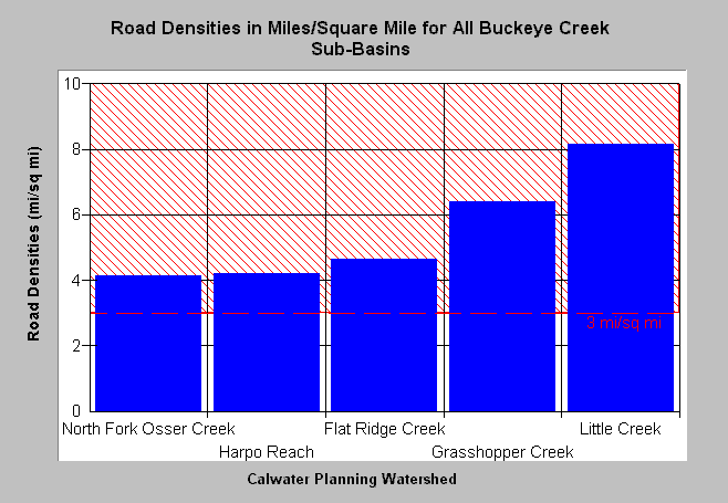
| Caption: The Chart above shows the density of roads in miles per square mile for Buckeye Creek basin Calwaters. The highest road densities are in the Little Creek (8.1 mi/sq mi) and Grasshopper Creek (6.4 mi/sq mi) Calwater areas and are associated with timber harvest. The North Fork Osser Creek, Harpo Reach and Flatridge Creek Calwaters have lower road densities, but are still over the threshold of three miles per square mile. The latter reference is derived from Cedarholm et al. (1984). Roads mapped by UC Davis ICE for NCRWQCB as part of TMDL and densities calculated by KRIS IFR staff. See Info Links for more information. See Picture for a map of roads in this area from the KRIS Gualala Map project. | |
 |
To learn more about this topic click Info Links .
To view a table of information about this data click Metadata .
To view the table with the chart's data, click Chart Table web page.
To download the table with the chart's data, click roaddensbc.dbf (size 1,221 bytes) .
To view the table with the chart's source data, click Source Table web page.
To download the table with the chart's source data, click roaddensgual2.dbf (size 4,565 bytes)
| www.krisweb.com |