
| Area | Buckeye Creek |
| Topic | USFS Riparian Tree Size Classes: Little Creek CalWater 1994 |
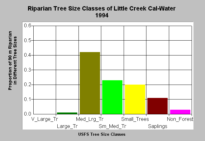
| Caption: This bar chart shows vegetation and timber types of the riparian zone of the Little Creek Calwater planning watershed, in lower Buckeye Creek. The U.S. Forest Service derived the information from a 1994 Landsat image. This analysis technique calculates averages of vegetation stands at a one-hectare scale. The high prevalence of smaller diameter size classes in the riparian zone of the streams in this Calwater, including lower mainstem Buckeye Creek, promotes stream warming and also presents a problem with regard to large wood recruitment. Scroll down for a key to classifications. Vegetation classifications are: Very Large Trees = >40" in diameter Large Trees = Trees 30-39.9" in diameter Medium/Large Trees = 20-29.9" in diameter Small/Medium Trees = 12-19.9" in diameter Small Trees = 5-11.9" in diameter Saplings = Trees less than 5" Non-Forest = No trees, shrubs, grass, bare soil | |
 |
To learn more about this topic click Info Links .
To view a table of information about this data click Metadata .
To view the table with the chart's data, click Chart Table web page.
To download the table with the chart's data, click rip_veg_sum_xtab-gual2.dbf (size 4,207 bytes) .
To view the table with the chart's source data, click Source Table web page.
To download the table with the chart's source data, click veggua_summstats.dbf (size 5,898 bytes)
| www.krisweb.com |