
| Area | Basin-wide/General |
| Topic | Habitat: Embeddedness at Pool Tails (All) |
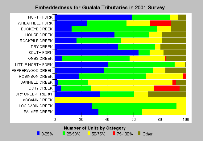
| Caption: This Chart shows cobble and gravel embeddedness from 2001 California Department of Fish and Game habitat typing surveys with results arrayed by stream order with highest orders at the top. This metric describes the degree to which potential salmonid spawning substrate at pool tails is buried or embedded. Less than 25% embedded (blue) is optimal salmonid spawning habitat, 25-50% (light green) moderately impaired and 50-75% and 75-100% are highly to severely impaired. A fifth category is used to describe pool tails otherwise unsuitable for spawning (log, plank, rock, concrete sill, bedrock sheet, etc.). The best values for salmonid spawning appear in the South Fork and North Fork Gualala reaches surveyed while other streams like Doty Creek and Danfield Creek show relatively impaired conditions. Survey lengths vary; therefore, please consult Topic Habitat: All Gualala Reach Lengths or see the Chart Table. Embeddedness estimates are visual and involve some subjectivity. See Info Links for more information. | |
 |
To learn more about this topic click Info Links .
To view a table of information about this data click Metadata .
To view the table with the chart's data, click Chart Table web page.
To download the table with the chart's data, click streamsum_m_gua_habdata.dbf (size 11,384 bytes) .
To view the table with the chart's source data, click Source Table web page.
To download the table with the chart's source data, click reachsum_m_gua_habdata.dbf (size 15,911 bytes)
| www.krisweb.com |