
| Area | Basin-wide/General |
| Topic | Sediment: Road Densities for All Gualala River Planning Watersheds |
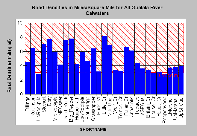
| Caption: The Chart above shows the density of roads in miles per square mile for all Gualala River Cal-water planning watersheds. The highest road densities tend to be in the northern and western basins where industrial timber harvest is the primary land use. Road densities are lower in the eastern Gualala watershed where unstable terrain of the Central Belt Franciscan Formation predominates. Roads mapped by UC Davis ICE for NCRWQCB as part of TMDL and densities calculated by KRIS IFR staff in Arc Info. See Picture for a map of basin wide roads from the KRIS Gualala Map project. See Info Links for an explanation of reference line. | |
 |
To learn more about this topic click Info Links .
To view a table of information about this data click Metadata .
To view the table with the chart's data, click Chart Table web page.
To download the table with the chart's data, click roaddensgual2.dbf (size 4,565 bytes) .
To view the table with the chart's source data, click Source Table web page.
To download the table with the chart's source data, click roaddensgual2.dbf (size 4,565 bytes)
| www.krisweb.com |