
| Area | North Fork |
| Topic | Timber Harvest: Percent Harvested North Fk Gualala Calwaters 1991-2001 |
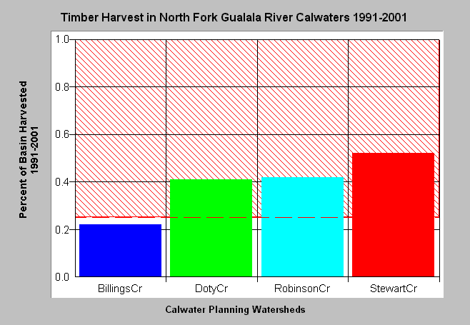
| Caption: The chart above shows the percent area of North Fork Gualala Basin Calwater Planning Watersheds permitted for timber harvests between 1991 and 2001 according to the California Department of Forestry, Santa Rosa office. All basins except Billings Creek had permitted harvest rates over 40% in the period between 1991 and 2001. Values are sums without subtraction for overlapping THPs, and do not represent harvest from plans approved in 1985-1990 (see Picture Tab) yet delayed for up to five years. THPs permitted since 1999 may not yet have been cut. For full names of Calwaters, see the Chart Table. The threshold of 25% harvest is after the Reeves et al. (1993) finding that diversity of salmonids in Oregon coastal streams was diminished when basins were harvested over this level. See Info Links for more information. | |
 |
To learn more about this topic click Info Links .
To view a table of information about this data click Metadata .
To view the table with the chart's data, click Chart Table web page.
To download the table with the chart's data, click thp_nf_cw.dbf (size 2,526 bytes) .
To view the table with the chart's source data, click Source Table web page.
To download the table with the chart's source data, click kristhpsumm.dbf (size 9,916 bytes)
| www.krisweb.com |