
| Area | North Fork |
| Topic | USFS Riparian Tree Size Classes: NF Comparison 1994 |
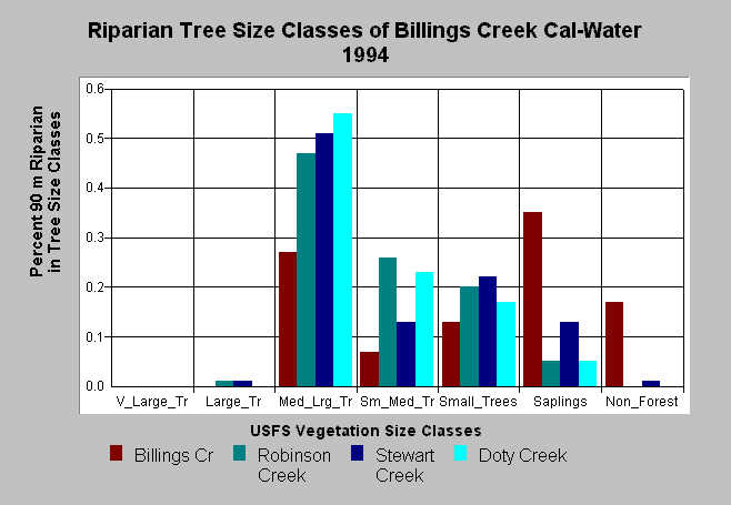
| Caption: This bar chart shows vegetation and timber size classes of the riparian zone of the all North Fork Gualala Calwater Planning Watersheds. The U.S. Forest Service derived the information from a 1994 Landsat image. This analysis technique calculates averages of vegetation stands at a one-hectare scale. The Billings Creek riparian zone had a high amount of Non-Forest (17%) because it has large areas of natural grassland related to Central Belt Franciscan terrain. The largest vegetation type component is saplings (1"-4.9" diameter), which may reflect hardwood forest associated with grasslands in part. Medium-Large Trees (20-29.9") were 27% of the watershed area, Small-Medium Trees (12-19.9" diameter) made up 7% of the watershed and Small Trees 13%. Click on Picture to see an Arc View scene of the North Fork Calwater planning watersheds showing riparian vegetation types. Vegetation classifications are: Very Large Trees = >40" in diameter Large Trees = Trees 30-39.9" in diameter Medium/Large Trees = 20-29.9" in diameter Small/Medium Trees = 12-19.9" in diameter Small Trees = 5-11.9" in diameter Saplings = Trees less than 5" Non-Forest = No trees, shrubs, grass, bare soil | |
 |
To learn more about this topic click Info Links .
To view a table of information about this data click Metadata .
To view the table with the chart's data, click Chart Table web page.
To download the table with the chart's data, click rip_veg_sum_xtab-gual2.dbf (size 4,207 bytes) .
To view the table with the chart's source data, click Source Table web page.
To download the table with the chart's source data, click veggua_summstats.dbf (size 5,898 bytes)
| www.krisweb.com |