| Area |
North Fork |
| Topic |
North Fork Gualala Location Maps |
 Click on image to enlarge (183K).
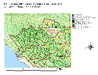
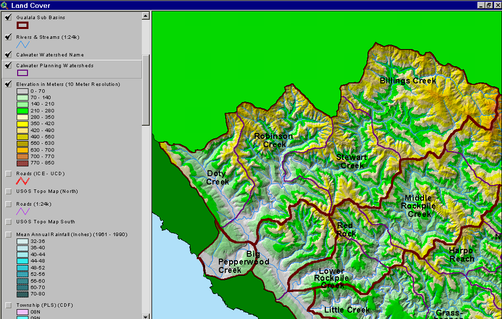
The image above is from the KRIS Gualala Map project and shows the elevation and relief of the North Fork Gualala watershed. The lowest reaches of the North Fork Gualala are low relief but elevation rises sharply in the north and east in the Robinson Creek and Billings Creek Calwaters, respectively. The Little North Fork (in Doty Creek Calwater) follows the trace of the San Andreas Fault.
 Click on image to enlarge (120K).
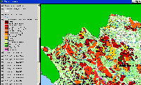
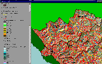
The image above comes from the KRIS Gualala Map project and shows timber harvests as mapped by the California Department of Forestry by year from 1991-2001. The timber harvests shown above are for the entire basin and have been approved but may not have been implemented.
 Click on image to enlarge (105K). Click here to display a larger version (445K).
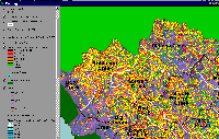
The image above is from the KRIS Gualala Map project and shows stream gradient for the North Fork Gualala basin. The large extent of stream reaches with gradient less than two percent (light and dark blue) shows why the North Fork Gualala was once a substantial producer of coho salmon. Mild gradients such as these were optimal for this species for both spawning and rearing. The reaches colored red are the steepest tributary areas, which tend to occur at headwaters in the northern and eastern portion of the basin. A useful stream classification for gradient is from Lunetta et al. (1995) with streams less than 4% being response reaches, 4-12% transport reaches and greater than 12% being supply reaches.
 Click on image to enlarge (82K).
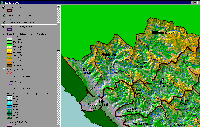
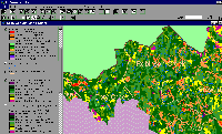
The image above is from the KRIS Gualala Map project and shows vegetation for the North Fork basin as interpreted from a 1994 Landsat image by the U.S. Forest Service Remote Sensing Lab in Sacramento. The eastern part of the Gualala basin is underlain by Central Belt Franciscan terrain and is, therefore, naturally in grasslands, oak woodlands and mixed oak. The best coniferous timberland is in the western portions of the North Fork basin with small diameter classes predominating because of active, recent timber harvest. See Vegetation and Timber Size Class topics for more in depth information.
 Click on image to enlarge (141K). Click here to display a larger version (247K).
The image above shows riparian tree size within 90 meters of either side of the North Fork Gualala and its tributaries derived from a 1994 Landsat data. While the upper North Fork (Billings Creek Calwater) may have naturally high components of small diameter trees and Non Forest due to bedrock geology, the young age of the riparian forest in the western North Fork basin is owing to timber harvest. Natural open canopy conditions in the upper basin leave the stream open to warming but small diameter trees in the western basin also promote warming and indicate a lack of potential large wood for recruitment into the stream for salmonid habitat.
 Click on image to enlarge (147K).
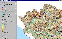
The image above comes from the KRIS Gualala Map project and shows roads and Calwaters for the NF Gualala River. Road densities are low in the highly erodible earthflow terrain in the eastern portions of the watershed. Road densities are highest in industrial timberland holdings in the western and northwestern portions of the North Fork Gualala basin. The road data were generated by the University of California Davis ICE project for the California Water Resources Control Board as part of the Gualala TMDL.
 Click on image to enlarge (171K).
The map image above is of the shallow landslide stability model (SHALSTAB) generated from a ten-meter digital elevation model (DEMs) for the North Fork Gualala with higher risk of shallow landslides coded in colors from yellow to red. Most of the basin, except for the west side of the Little North Fork (Doty Cr Calwater) and parts of Billings Creek are in very high-risk areas. Inner gorge locations and headwater swales show a pattern of high risk throughout the North Fork basin. The SHALSTAB run was performed by Dr. Jan Derksen based on 10m DEM data provided by the California Department of Forestry FRAP division. See the Background page Slope Stability for more information.
 Click on image to enlarge (84K).
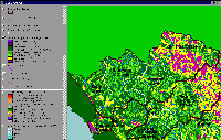
This map shows the western North Fork Gualala basin and USFS vegetation type and tree size class along with change scene detection. The latter is a comparison of the 1994 and 1998 Landsat images and shows where ground cover has been reduced or increased. Red and orange areas indicate places where timber harvest took place between 1994 and 1998. Change scene data are from the California Department of Forestry Fire and Resources Assessment Program (FRAP).
To learn more about this topic click Info Links

 Click on image to enlarge (183K).
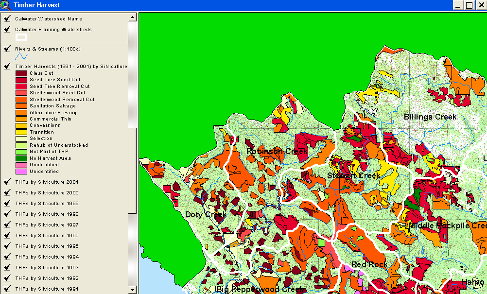 Click on image to enlarge (120K).
 Click on image to enlarge (105K). Click here to display a larger version (445K).
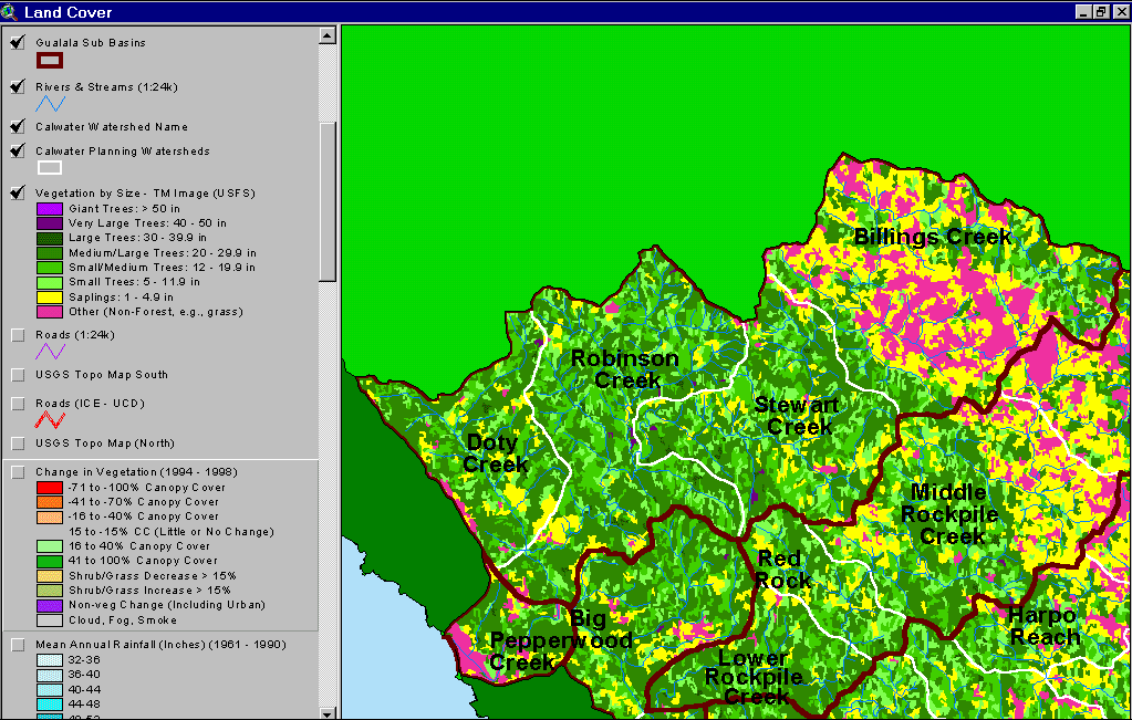 Click on image to enlarge (82K).
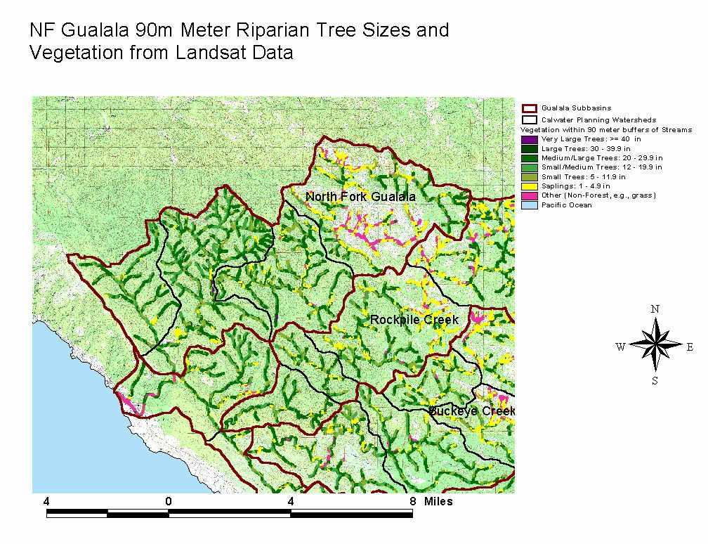 Click on image to enlarge (141K). Click here to display a larger version (247K).
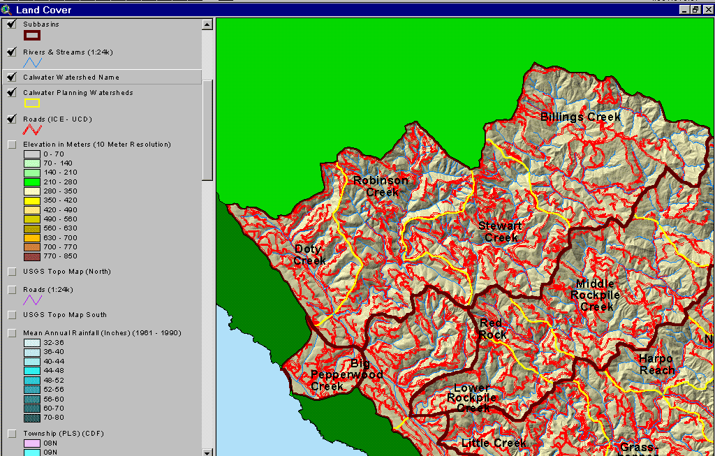 Click on image to enlarge (147K).
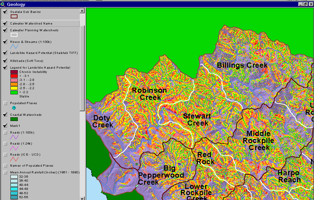 Click on image to enlarge (171K).
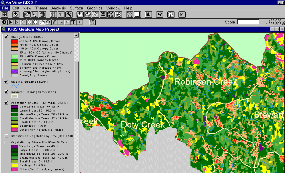 Click on image to enlarge (84K).
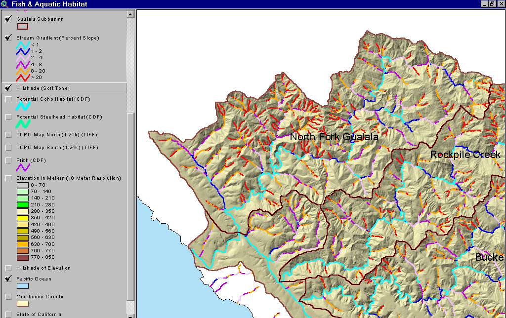