
| Area | Rockpile Creek |
| Topic | Sediment: Road Densities for Rockpile Creek Calwaters |
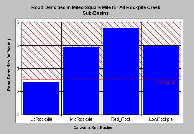
| Caption: The Chart above shows the density of roads in miles per square mile for Rockpile Creek basin Calwaters. The highest road densities are in the Red Rock (7.5 mi/sq mi) Middle Rockpile Creek (5.9 mi/sq mi) and Lower Rockpile Creek (5.9 mi/sq mi) Calwater areas and are associated with timber harvest. The Upper Rockpile Creek Calwater has lower road densities because it is largely within the Central Belt Franciscan Formation, which makes it difficult to build and maintain roads. The threshold of 3 miles per square mile comes from Cedarholm et al. (1984). Roads mapped by UC Davis ICE for NCRWQCB as part of TMDL and densities calculated by KRIS IFR staff. See Info Links for more information. See Picture for a map of roads in this area from the KRIS Gualala Map project. | |
 |
To learn more about this topic click Info Links .
To view a table of information about this data click Metadata .
To view the table with the chart's data, click Chart Table web page.
To download the table with the chart's data, click roaddensrc.dbf (size 1,106 bytes) .
To view the table with the chart's source data, click Source Table web page.
To download the table with the chart's source data, click roaddensgual2.dbf (size 4,565 bytes)
| www.krisweb.com |