
| Area | South Fork |
| Topic | Temperature: Seasonal Maxima for Main/South Fork Watershed Celsius |
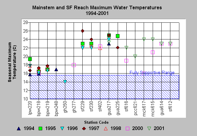
| Caption: The chart above shows the maximum water temperature for all automated temperature probes placed in the South Fork Gualala River from 1994 to 2001. Station location codes are pw = Big Pepperwood Creek, sf = South Fork Gualala River, gua = mainstem Gualala and mck = McKenzie Creek. Readings range from fully functional at station gh250 and some Big Pepperwood Creek sites; to moderately stressful for salmonids at other reaches of Big Pepperwood, to highly stressful or lethal (>25 C) in the mainstem Gualala and South Fork Gualala River. One time maximum temperatures do not provide information on duration of stress and so are not definitive for gauging suitability for salmonids. See Info Links for more information. Data provided by Gualala Redwoods, Inc. and the Gualala River Watershed Council. | |
 |
To learn more about this topic click Info Links .
To view a table of information about this data click Metadata .
To view the table with the chart's data, click Chart Table web page.
To download the table with the chart's data, click mainmax.dbf (size 2,162 bytes) .
| www.krisweb.com |