
| Area | South Fork |
| Topic | Temperature: Yearly MWATs for Main/South Fork Watershed Fahrenheit |
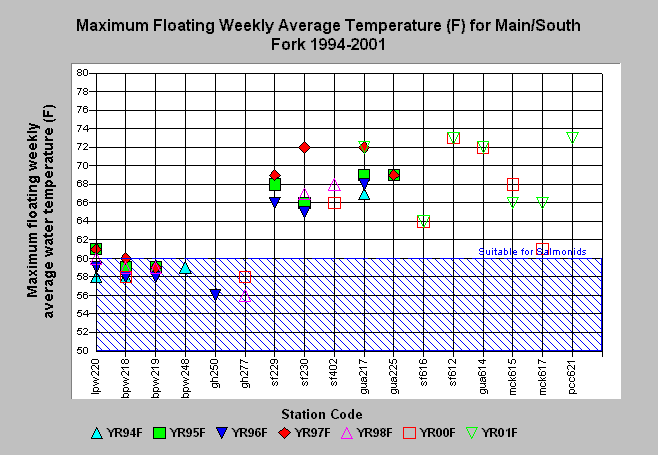
| Caption: The chart above shows the maximum floating weekly average water temperature (MWAT) for all automated temperature probes placed in the South Fork Gualala River from 1994 to 2001. Station location codes are lpw and bpw = Little and Big Pepperwood creeks, sf = South Fork Gualala River, gua = mainstem Gualala and mck = McKenzie Creek. Readings indicate that Big Pepperwood and stations gh250 and gh277 are fully supportive of salmonids. All other stations are moderate to highly impaired with regard to salmonid suitability. Mainstem Gualala station gua 217 appears to show a pattern of increasing temperature. See Info Links for more information. Data provided by Gualala Redwoods, Inc. and the Gualala River Watershed Council. | |
 |
To learn more about this topic click Info Links .
To view a table of information about this data click Metadata .
To view the table with the chart's data, click Chart Table web page.
To download the table with the chart's data, click mainmwat.dbf (size 2,250 bytes) .
| www.krisweb.com |