
| Area | South Fork |
| Topic | Sediment: Road Densities for Mainstem/SF Gualala Planning Watersheds |
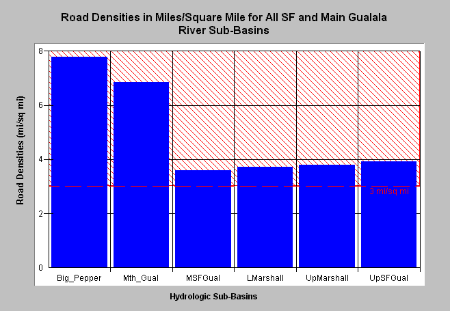
| Caption: The Chart above shows the density of roads in miles per square mile for South Fork and Mainstem Gualala basin planning watersheds. The highest road densities are in the Big Pepperwood (Big_Pepper) and Mouth of the Gualala (Mth_Gual) planning watersheds with 7.8 and 6.8 miles per square mile, respectively. Roads mapped by UC Davis ICE for NCRWQCB as part of TMDL and densities calculated by KRIS IFR staff in ArcInfo. The threshold of 3 miles per square mile comes from Cedarholm et al. (1984). See Info Links for more information. See Picture for a map of roads in this area from the KRIS Gualala Map project. | |
 |
To learn more about this topic click Info Links .
To view a table of information about this data click Metadata .
To view the table with the chart's data, click Chart Table web page.
To download the table with the chart's data, click roaddenssf.dbf (size 1,336 bytes) .
To view the table with the chart's source data, click Source Table web page.
To download the table with the chart's source data, click roaddensgual2.dbf (size 4,565 bytes)
| www.krisweb.com |