
| Area | Wheatfield |
| Topic | Habitat: Habitat Types by Percent Survey Length Wheatfield Tribs 2001 |
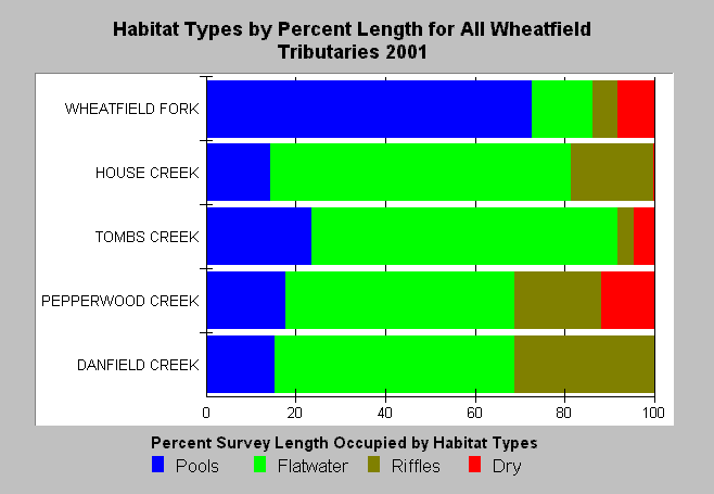
| Caption: The California Department of Fish and Game habitat surveys in the Gualala basin in 2001 provide data that can be classified as four basic types of units (pools, flatwater, riffles and dry channel). The percent stream length composed of pools (blue bar) is an important descriptor of habitat quality for salmonids, as juvenile coho and older age steelhead require pool habitat for rearing. The highest order stream, the Wheatfield Fork, appears at the top of the chart and pool habitat is the predominant habitat category. All other streams surveyed have low pool frequencies with most having values less than 20% by length. Extensive dry reaches in the Wheatfield Fork and Pepperwood Creek also indicate poor conditions for rearing salmonids. See Info Links for more information. | |
 |
To learn more about this topic click Info Links .
To view a table of information about this data click Metadata .
To view the table with the chart's data, click Chart Table web page.
To download the table with the chart's data, click stream_sum_wf.dbf (size 7,102 bytes) .
To view the table with the chart's source data, click Source Table web page.
To download the table with the chart's source data, click streamsum_m_gua_habdata.dbf (size 11,384 bytes)
| www.krisweb.com |