
| Area | Wheatfield |
| Topic | Sediment: Road Densities for Wheatfield Fork Calwaters |
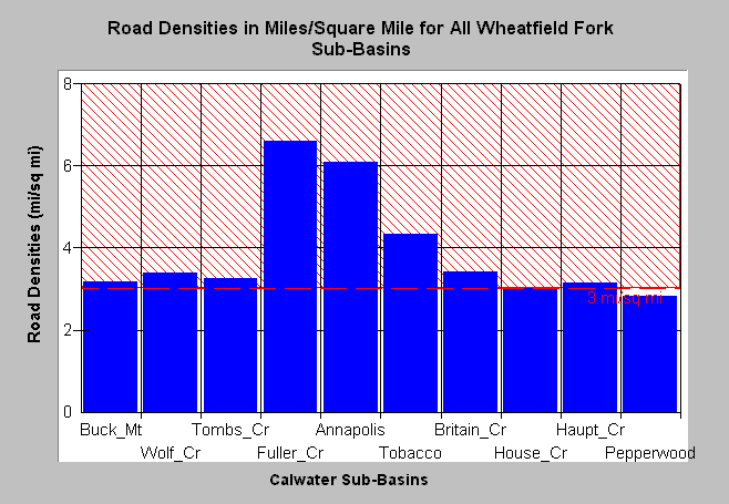
| Caption: The Chart above shows the density of roads in miles per square mile for Wheatfield basin Calwaters. The highest road densities are in the Fuller Creek (6.6 mi/sq mi), Annapolis (6.1 mi/sq mi) and Tobacco Creek (4.3 mi/sq mi) Calwater areas. Many of the roads in Fuller Creek are currently undergoing upgrading or decomissioning. The Calwaters in the eastern Wheatfield have lower road densities. The reference line of of three miles per square mile is based in Cedarholm et al. (1984). Roads mapped by UC Davis ICE for NCRWQCB as part of TMDL and densities calculated by KRIS IFR staff. See Info Links for more information. See Picture for a map of roads in this area from the KRIS Gualala Map project. | |
 |
To learn more about this topic click Info Links .
To view a table of information about this data click Metadata .
To view the table with the chart's data, click Chart Table web page.
To download the table with the chart's data, click roaddenswf.dbf (size 1,796 bytes) .
To view the table with the chart's source data, click Source Table web page.
To download the table with the chart's source data, click roaddensgual2.dbf (size 4,565 bytes)
| www.krisweb.com |