| Basin |
Humboldt Bay |
| Caption |
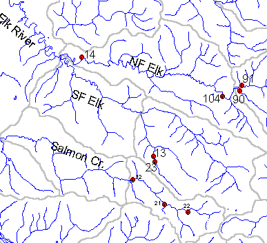
Map from Institute for Fisheries Resources KRIS Coho map project and shows approximate location of PL Elk River sampling stations. Aquatic insect data is available from only stations 13,14 and 23. |
| CaptionTemplate |
[Description] |
| Description |
Map from Institute for Fisheries Resources KRIS Coho map project and shows approximate location of PL Elk River sampling stations. Aquatic insect data is available from only stations 13,14 and 23. |
| Filename |
erplstat.gif |
| Filesize |
10531 |
| Meta_Id |
insects |
| Notefile |
humbay.htm#AqInsects |
| Path |
topics/er/erplstat.gif |
| Series |
GIS: PALCO Aquatic Invertebrate, Sediment, Temperature Sampling Locations in late 1990s |
| SubBasin |
Elk River |