|
Area/Topic | Bibliography | Background | Hypotheses | Home |
Photo Pages: Meta Information
This page contains detailed information from the KRIS Photodatabase table about photos from sub-basin Elk River and series GIS: Vegetation Types in Elkhead CW Watershed 1994.
| Basin | Humboldt Bay |
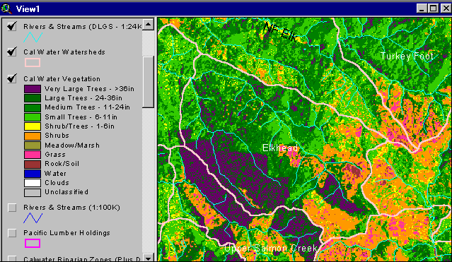
| Caption | This map image of vegetation types is based 1994 Landsat data and shows vegetation types for the Elk River watershed. The significant amount of shrubs and grass (orange and pink) in the South Fork Elk River watershed indicate a high degree of recent disturbance. The large purple area to the southwest (lower left) of the watershed is the Headwaters Forest in the Little South Fork Elk drainage (see next Picture for aerial photo of watershed). Map based on data from Humboldt State University but with summaries and final map legend by Institute for Fisheries Resources. |
| CaptionTemplate | [Description] |
| Description | This map image of vegetation types is based 1994 Landsat data and shows vegetation types for the Elk River watershed. The significant amount of shrubs and grass (orange and pink) in the South Fork Elk River watershed indicate a high degree of recent disturbance. The large purple area to the southwest (lower left) of the watershed is the Headwaters Forest in the Little South Fork Elk drainage (see next Picture for aerial photo of watershed). Map based on data from Humboldt State University but with summaries and final map legend by Institute for Fisheries Resources. |
| Filename | elkhead.gif |
| Filesize | 46779 |
| Meta_Id | VegType |
| Notefile | humbay.htm#Seral |
| Path | topics/er/elkhead.gif |
| Series | GIS: Vegetation Types in Elkhead CW Watershed 1994 |
| SubBasin | Elk River |
| Agency | Doug Thron Nature Photography |
| Basin | Humboldt Bay |
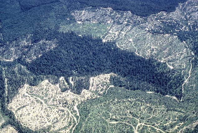
| Caption | This aerial photo shows large trees surrounded by early successional vegetation such as shrubs, grass and small trees as well as bare soil. The polygon of old trees (purple on Landsat) and surrounding clear cuts in early seral (red and orange on Landsat) are distinguishable in Picture 1 map image. Photo courtesy of and copyright by Doug Thron Nature Photography. Flight used for photo opportunity provided by Project Lighthawk |
| CaptionTemplate | [Description] |
| Description | This aerial photo shows large trees surrounded by early successional vegetation such as shrubs, grass and small trees as well as bare soil. The polygon of old trees (purple on Landsat) and surrounding clear cuts in early seral (red and orange on Landsat) are distinguishable in Picture 1 map image. Photo courtesy of and copyright by Doug Thron Nature Photography. Flight used for photo opportunity provided by Project Lighthawk |
| Filename | thron7.jpg |
| Filesize | 117652 |
| Meta_Id | VegType |
| Notefile | humbay.htm#Seral |
| Path | topics/er/thron7.jpg |
| Photographer | Doug Thron |
| Restriction | Photo courtesy of and copyright by Doug Thron Nature Photography |
| Series | GIS: Vegetation Types in Elkhead CW Watershed 1994 |
| SubBasin | Elk River |
| www.krisweb.com |