
| Area | Basin-wide/Regional |
| Topic | Climate: Annual Rainfall Eureka 1905-2005 |
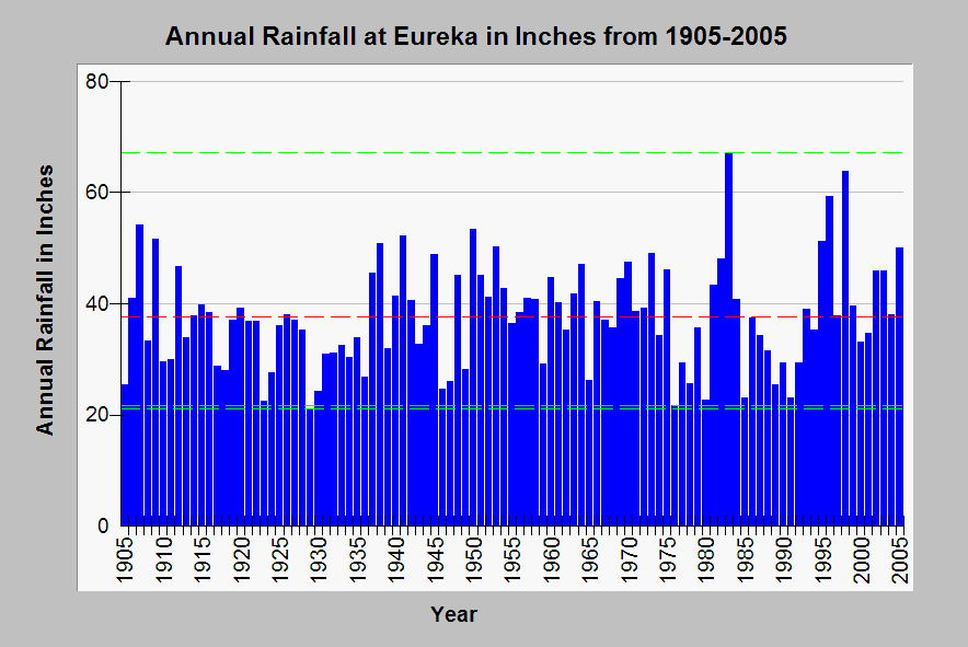
| Caption: The graph above shows annual rainfall in inches at Eureka from 1905 to 2005. Green bounding lines show highest and lowest rainfall totals with red line indicating mean annual rainfall. Note that one of the wettest years in the period was 1983, an El Nino year. Between 1986 and 1992 there was a prolonged drought, but 1995 was very wet with storms in January, March and December. Wet years are more likely to trigger erosion than dry years, although storm intensity is a more significant factor. Data from the California Data Exchange Center. | |
 |
To learn more about this topic click Info Links .
To view additional information (data source, aquisition date etc.) about this page, click Metadata .
To view the table with the chart's data, click Chart Table web page.
To download the table with the chart's data, click rainfall_eka_yr_1905_2005_annual.db (size 4,096 bytes)
To download the table with the chart's data as an Excel spreadsheet, click rainfall_eka_yr_1905_2005_annual.db.xls (size 10,752 bytes) .
| www.krisweb.com |