
| Area | Middle Klamath |
| Topic | VegType: Grider Creek Watershed 1994 |
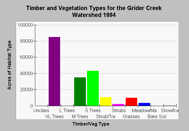
| Caption: The chart above shows vegetation types and timber size classes by acre of the Grider Creek watershed as derived from a 1994 Landsat image. The Landsat image was classified using the WHR method by the Humboldt State University Spatial Analysis Laboratory then modified for use in KRIS (see Info Links). The distribution of tree size classes and vegetation types suggests that the watershed has been lightly impacted by timber harvest. Grider has its headwaters in the Marble Mountain Wilderness Area. Classes include: Very Large Trees = 36" in diameter or greater, Large Trees = 24-36" in diameter, Medium Trees = 11-24" in diameter, Small Trees = 6-11" in diameter, Small Trees/Shrubs = Trees 1-6" in diameter and shrubs, Shrubs, Grass, Rock/Soil, Marsh/Meadow. | |
 |
To learn more about this topic click Info Links .
To view additional information (data source, aquisition date etc.) about this page, click Metadata .
To view the table with the chart's data, click Chart Table web page.
To download the table with the chart's data, click kriseral.dbf (size 1,748 bytes) .
| www.krisweb.com |