
| Area | Middle Klamath |
| Topic | VegType: Red Cap Creek Watershed 1994 |
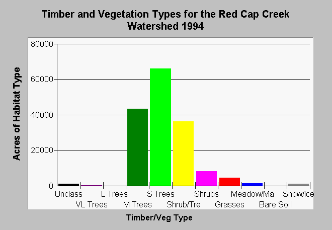
| Caption: The chart above shows vegetation types and timber size classes by acre of the Red Cap Creek watershed as derived from a 1994 Landsat image. The Landsat image was classified using the WHR method by the Humboldt State University Spatial Analysis Laboratory then modified for use in KRIS (see Info Links). Red Cap Creek is a Key Watershed under the Northwest Forest Plan and the high number of medium trees (11-24" diameter) indicates substantial tracts of old trees remain in the watershed. The high component of small trees (6-12 inches diameter) and small trees (<6 inches) and shrubs indicates may be owing to soil conditions in the upper watershed or timber harvest areas that were cut in the 1970s and have not regenerated. Grasslands may be in part natural along upper ridges. Classes include: Very Large Trees = 36" in diameter or greater, Large Trees = 24-36" in diameter, Medium Trees = 11-24" in diameter, Small Trees = 6-11" in diameter, Small Trees/Shrubs = Trees 1-6" in diameter and shrubs, Shrubs, Grass, Rock/Soil, Marsh/Meadow. | |
 |
To learn more about this topic click Info Links .
To view additional information (data source, aquisition date etc.) about this page, click Metadata .
To view the table with the chart's data, click Chart Table web page.
To download the table with the chart's data, click kriseral.dbf (size 1,748 bytes) .
| www.krisweb.com |