
| Area | Mainstem Klamath |
| Topic | Flow: Peak Flows at Seven Klamath River Gauges 1964,1974,1997 |
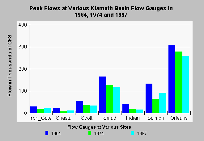
| Caption: The chart above shows a comparison of stream flows at several Klamath Basin locations for major floods in 1964, 1974 and 1997. Flows are in thousands of cubic feet per second. This data summary was provided by Klamath National Forest as part of the 1997 storm damage assessment. Flows related to the 1997 storm were not as high as the 1964 flood as indicated by lower stream flows at all stations measured. Flows in 1974 exceeded those of 1997 except in the Salmon River. Comparisons also include flows of the Klamath River at Iron Gate, Seiad Valley and Orleans as well as Indian Creek, the Scott River and Shasta River. Original source of data USGS and Klamath National Forest. See Info Links for more information. | |
 |
To learn more about this topic click Info Links .
To view additional information (data source, aquisition date etc.) about this page, click Metadata .
To view the table with the chart's data, click Chart Table web page.
To download the table with the chart's data, click floodflw.dbf (size 421 bytes) .
| www.krisweb.com |