
| Area | Middle Trinity |
| Topic | Sediment: Upper Middle Trinity - Road Densities 2001 |
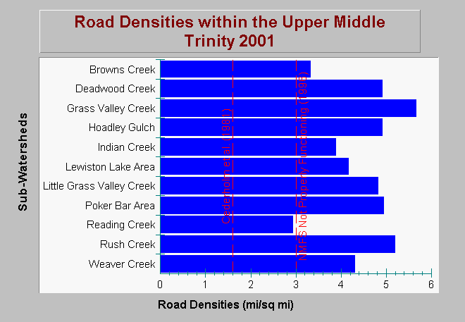
| Caption: The chart above shows road densities in miles per square mile within the Upper Middle Trinity River Planning Watershed as of 2001. Road densities in all sub-watersheds, except Reading Creek, exceed the properly functioning condition according to the National Marine Fisheries Service (1996), which is less than 3 miles per square mile. All sub-watersheds exceed the salmonid survival reference determined by Cederholm et. al. (1981) of 1.6 miles per square mile. Road data may not include temporary roads and skid trails, which makes road density values conservative. Data were provided by Graham Matthews and Associates (2001). Click on Info Links for more background information. | |
 |
To learn more about this topic click Info Links .
To view additional information (data source, aquisition date etc.) about this page, click Metadata .
To view the table with the chart's data, click Chart Table web page.
To download the table with the chart's data, click sed_roads_umt_gma_2001.dbf (size 1,225 bytes) .
To view the table with the chart's source data, click Source Table web page.
To download the table with the chart's source data, click sed_roads_densities_erosion_trinity_pw_gma_2000.dbf (size 6,112 bytes)
| www.krisweb.com |