
| Area | Shasta |
| Topic | Total Dissolved Solids: At Seven Shasta Stations |
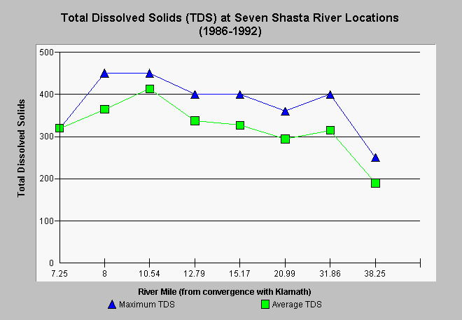
| Caption: Data on total dissolved solids displayed above was collected by the North Coast Regional Water Quality Control Board staff and reflects samples from 1986 to 1992 (see Source Table). To see an index of sample locations by river mile (rm), you may scroll to the bottom of this text field. Shasta River total dissolved solids increase substantially in a downstream direction with highest levels often found below the Montague-Grenada Road (river mile 10.54). TDS can stem from many sources. Elevated levels in the lower Shasta Valley may result from mineralized spring flow and nutrient and mineral enrichment resulting from agricultural runoff. Locations by river mile of sampling stations are: Highway 263 = rm 7.25, Anderson Grade Rd. = rm 8, Yreka-Ager Rd. = 10.54, Highway 3 = rm 12.79, Montague/Grenada Rd = 15.17, A-12 = rm 20.99, East Louie Rd. = 31.86, Riverside Dr. = 37.73. | |
 |
To learn more about this topic click Info Links .
To view additional information (data source, aquisition date etc.) about this page, click Metadata .
To view the table with the chart's data, click Chart Table web page.
To download the table with the chart's data, click gwlabda1.dbf (size 618 bytes) .
To view the table with the chart's source data, click Source Table web page.
To download the table with the chart's source data, click gwlabdat.dbf (size 33,850 bytes)
| www.krisweb.com |