
| Area | Shasta |
| Topic | Dissolved Oxygen: Max/Avg at Four Shasta Locations in 1994 |
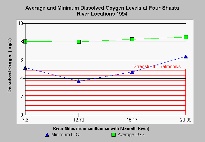
| Caption: The California Department of Fish and Game (CDFG) monitored dissolved oxygen (D.O.) at several sites established by Gwynne (1993) along the Shasta River in 1994. Average and minimum D.O. are displayed above for four locations. D.O. less than 5 milligrams per liter (mg/L) are stressful to salmonids. These data shows similar trends to those described by North Coast Regional Water Quality Control Board staff in earlier years. The lowest readings were still at Highway 3 (rm12.79) with no problems in D.O. displayed at County Road A-12 (rm 20.99). Lows at Anderson Grade Road (rm 8) and Montague/Grenada Road (rm 15.17) did drop to stressful levels for salmonids. Click on Info Links for more information. | |
 |
To learn more about this topic click Info Links .
To view additional information (data source, aquisition date etc.) about this page, click Metadata .
To view the table with the chart's data, click Chart Table web page.
To download the table with the chart's data, click sharv1a.dbf (size 314 bytes) .
To view the table with the chart's source data, click Source Table web page.
To download the table with the chart's source data, click sharv1.dbf (size 30,618 bytes)
| www.krisweb.com |