
| Area | Shasta |
| Topic | Climate: Snow Pack Parks Creek 1946 to 1999 |
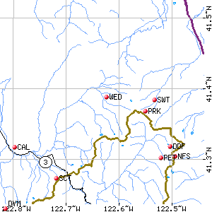
The map above shows the location of the Sweetwater and Parks Creek (PRK) snow gauging stations as shown on the California Data Exchange Center web site. The site is near the upper limits of the Parks Creek watershed and is just over the divide from the upper Trinity and EF Scott Basins.
 Click on image to enlarge (7K).
To learn more about this topic click Info Links
To view additional information (data source, aquisition date etc.) about this page, click Metadata
| www.krisweb.com |