
| Area | Basin-wide/Regional |
| Topic | Sediment: Fines <4.7 mm Mattole River and Lost Man Creek, 1990 |
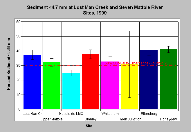
| Caption: The chart above shows the percent fine sediment less than 4.7 mm for September 1990 wet sieve McNeil bulk gravel samples in the Mattole River and Lost Man Creek. Bars represent the average of three McNeil cores at a station and whiskers represent standard deviation. All sites except Lost Man Creek are on the Mattole River and are listed in sequence, with the furthest downstream site on the far right. The reference value of 30% is derived from Kondolf (2000), which found a 50% survival to emergence for salmonid eggs and alevins when sediments <0.64 mm comprised 30% of substrate. The data displayed here is sediment <4.7 mm, thus the reference value is artificially high. See Chart Table for site locations. Data from Larry Preston, California Department of Fish and Game. See Info Links for more information. | |
 |
To learn more about this topic click Info Links .
To view a table of information about this data click Metadata .
To view the table with the chart's data, click Chart Table web page.
To download the table with the chart's data, click sed_matl_mcneil_preston.dbf (size 1,642 bytes) .
| www.krisweb.com |