
| Area | Basin-wide/Regional |
| Topic | Sediment: V* by NCRWQCB, 1992 & 1993 |
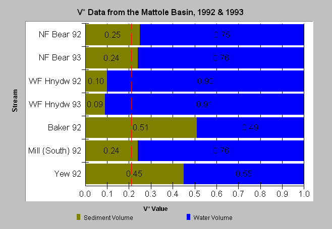
| Caption: This chart displays V* data from five streams in the Mattole Basin measured in 1992. V* is in decimal percent. A V* of 0.50 indicates that half of the pool is filled with fine sediment. The 0.21 target threshold is from the TMDL for the Big River and other North Coast Rivers. The West Fork of Honeydew Creek had a low V* value, the North Fork Bear River and Mill Creek had values slightly elevated above target threshold, while Baker Creek and Yew Creek had values more than twice as high as those established by TMDL target thresholds for Mendocino County. Values are from Knopp (1993). Data are provided by the North Coast Regional Water Quality Control Board. See Info Links for more information. | |
 |
To learn more about this topic click Info Links .
To view a table of information about this data click Metadata .
To view the table with the chart's data, click Chart Table web page.
To download the table with the chart's data, click knopp_vstar_mattole.dbf (size 965 bytes) .
To view the table with the chart's source data, click Source Table web page.
To download the table with the chart's source data, click knopp.dbf (size 12,582 bytes)
| www.krisweb.com |