
| Area | Basin-wide/Regional |
| Topic | Temperature: MWATs of Mainstem Mattole River (Fahrenheit) |
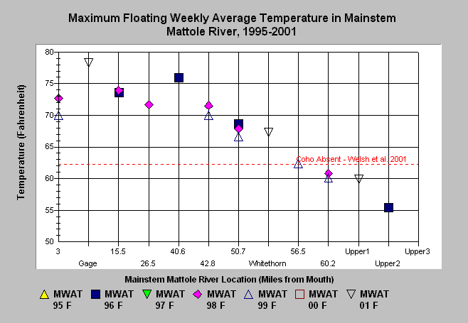
| Caption: This chart plots the maximum floating weekly average temperature (MWAT) for each measured site in the Mainstem Mattole River by year. Over fifty miles of the mainstem Mattole River exceeded the threshold associated with coho absence in the Mattole River basin (Welsh et al. 2001). Click on Picture to see site locations and localization of the upper four sites. Sites measured in multiple years show no trend but indicate that 1999 was a relatively cool year. Data was provided by the NCRWQCB and originated from several sources (see Chart Table). Also see Info Links for more information. | |
 |
To learn more about this topic click Info Links .
To view a table of information about this data click Metadata .
To view the table with the chart's data, click Chart Table web page.
To download the table with the chart's data, click temp_mwat_main.db (size 12,288 bytes) .
To view the table with the chart's source data, click Source Table web page.
To download the table with the chart's source data, click temp_mwats.xls.db (size 38,912 bytes)
| www.krisweb.com |