
| Area | Eastern Mattole |
| Topic | Habitat: Canopy by Type for Eastern Tribs |
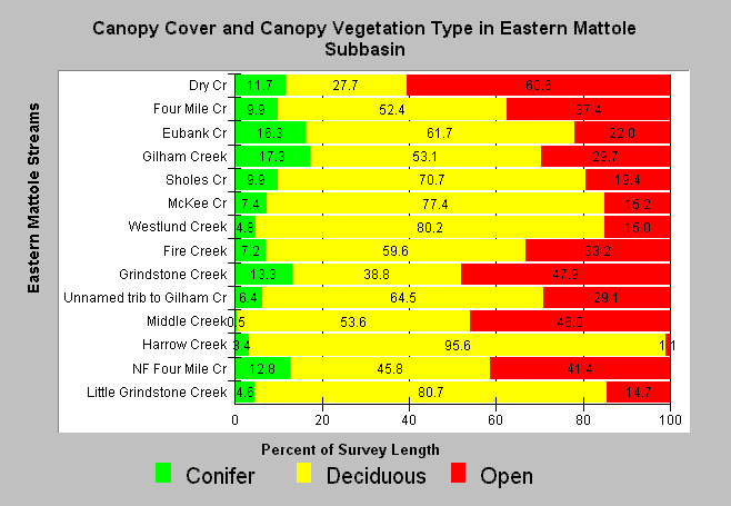
| Caption: Eastern Mattole streams were found to have 1-61% open canopy when surveyed by CDFG sometime between 1991-1999 (see Chart Table for survey dates). Most Eastern Mattole streams had less than 10% coniferous canopy. The streams are ranked by drainage area to with the largest at the top. Grindstone, Middle, and the North Fork Four Mile Creek had particularly high open canopy levels (41-48%) for small streams. Small streams with greater than 20% open canopy are considered unsuitable for maintaining cool water temperatures necessary for salmonid rearing. Click on Info Links for more information. | |
 |
To learn more about this topic click Info Links .
To view a table of information about this data click Metadata .
To view the table with the chart's data, click Chart Table web page.
To download the table with the chart's data, click hab_mat_ea_strm_m.dbf (size 10,000 bytes) .
To view the table with the chart's source data, click Source Table web page.
To download the table with the chart's source data, click hab_mattole_streamsum_m.dbf (size 29,582 bytes)
| www.krisweb.com |