
| Area | Estuary |
| Topic | WQ: Dissolved Oxygen in Mattole River Estuary, 1987 |
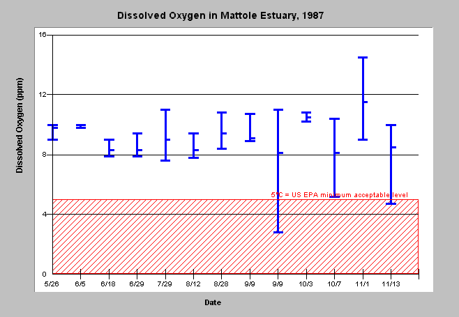
| Caption: The chart above shows minimum, maximum, and average dissolved oxygen measured in the Mattole River Estuary on 13 sampling days between June and November, 1987. Data was collected at 4 stations, with readings taken every vertical half-meter from water's surface down to the lagoon's bottom. Dissolved oxygen levels dropped below 5 ppm twice during the season. Both low readings occurred at station 2, which was sheltered from northwesterly winds and the water did not mix as readily as other sites. Day and night sampling periods are shown separately for September 9. The 5° C reference value was set by the US Environmental Protection Agency, as cited in Busby et al. (1988). Data collected by Busby, et al. (1988). See Info Links for more information. | |
 |
To learn more about this topic click Info Links .
To view a table of information about this data click Metadata .
To view the table with the chart's data, click Chart Table web page.
To download the table with the chart's data, click dissolved_oxy_chart.dbf (size 2,200 bytes) .
To view the table with the chart's source data, click Source Table web page.
To download the table with the chart's source data, click dissolved_oxy_source.dbf (size 8,028 bytes)
| www.krisweb.com |