
| Area | Northern Mattole |
| Topic | Timber Harvest: Percent Area Harvested, N. Mattole Subbasin 1983-2001 |
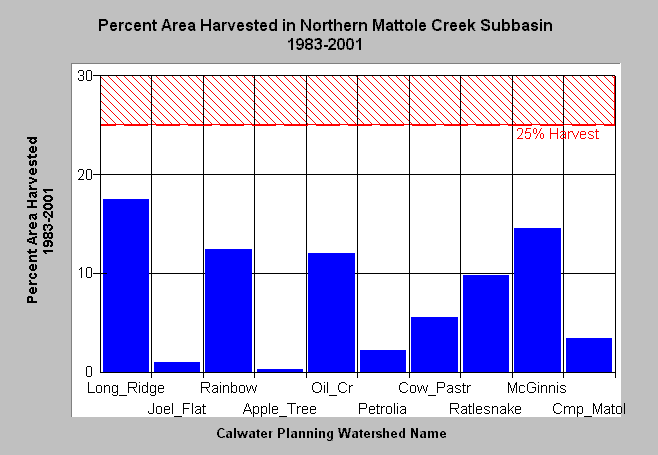
| Caption: The chart above shows the percent area of each Calwater Planning Watershed in the Northern Mattole Subbasin permitted for timber harvest between 1983 and 2001. The highest percent of timber harvest permitting occurred in the Long Ridge (17%) and the McGinnis Creek (15%) Calwater Planning Watersheds. These data were compiled from records of Timber Harvest Plans (THPs) approved by the California Department of Forestry, but the plans were not necessarily implemented. Areas were summed without subtracting for overlapping THPs, and do not include harvest from plans approved in 1977-1982 yet delayed for up to five years. The reference value of 25% harvest is shown because Reeves et al. (1992) found that the diversity of salmonids in Oregon coastal streams diminished when basins were harvested above that level. Click on the Picture Tab to see THP and digital orthophoto quadrangle images. | |
 |
To learn more about this topic click Info Links .
To view a table of information about this data click Metadata .
To view the table with the chart's data, click Chart Table web page.
To download the table with the chart's data, click thp_mat_amount_north.dbf (size 8,572 bytes) .
To view the table with the chart's source data, click Source Table web page.
To download the table with the chart's source data, click thp_mat_amount_source.dbf (size 23,862 bytes)
| www.krisweb.com |