
| Area | Southern Mattole |
| Topic | USFS VegTypes - Riparian Strips: Bridge Creek 1994 |
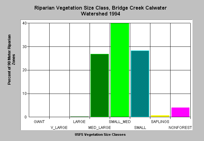
| Caption: This bar chart shows riparian tree size class of the Bridge Creek Calwater planning watershed. The U.S. Forest Service derived the information from a 1994 Landsat image. This analysis technique is accurate at the stand rather than individual tree level. Scroll down for a key to classifications. Click on Picture to see an ArcView screen capture of the Bridge Creek Calwater planning watershed showing vegetation types. Vegetation is classified according to diameter at breast height (DBH): Giant = >50" DBH, V Large = 40-50" DBH, Large = 30-40" DBH, Medium/Large = 20-30" DBH, Small/Medium = 12-20" DBH, Small = 5-12" DBH, Non-Forest = No trees, shrubs, grass, bare soil. | |
 |
To learn more about this topic click Info Links .
To view a table of information about this data click Metadata .
To view the table with the chart's data, click Chart Table web page.
To download the table with the chart's data, click vegusfs_rip.dbf (size 3,834 bytes) .
To view the table with the chart's source data, click Source Table web page.
To download the table with the chart's source data, click usfsveg_ripsrce.dbf (size 4,800 bytes)
| www.krisweb.com |