
| Area | Western Mattole |
| Topic | USFS VegTypes - Calwater Area: Squaw Creek 1994 |
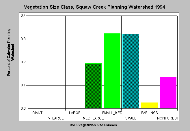
| Caption: This bar chart shows vegetation size class proportions from the Squaw Creek planning watershed. The U.S. Forest Service derived the information from a 1994 Landsat image. This analysis technique is accurate at the stand rather than individual tree level. Scroll down for a key to classifications. Click on Picture to see an image of this data from ArcView. Vegetation is classified according to diameter at breast height (DBH): GIANT = >50" DBH, V_LARGE = 40-50" DBH, LARGE = 30-40" DBH, MED_LARGE = 20-30" DBH, SMALL_MED = 12-20" DBH, SMALL = 5-12" DBH, NONFOREST = No trees, shrubs, grass, bare soil. Click on Info Links for more information. | |
 |
To learn more about this topic click Info Links .
To view a table of information about this data click Metadata .
To view the table with the chart's data, click Chart Table web page.
To download the table with the chart's data, click usfsveg_allcw.dbf (size 3,786 bytes) .
To view the table with the chart's source data, click Source Table web page.
To download the table with the chart's source data, click usfsveg_cwsrce.dbf (size 4,800 bytes)
| www.krisweb.com |