
|
Area/Topic | Bibliography | Background | Hypotheses | Home |
|
Map Page.
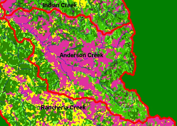
You selected the area Anderson Creek and the topic Map: 1F USFS Vegetation Size, Anderson Creek Sub-basin |
| This is a map of 1994 Landsat derived vegetation size data in the Anderson Creek sub-basin, displayed with 1:100,000 scale streams. The large Non-Forest component is as a result of agricultural activities in Anderson Valley and grassy uplands to the east, which are the result of underlying Central Belt Franciscan terrain. Data provided by the U.S. Forest Service Pacific Southwest Region Remote Sensing Lab, Sacramento, CA. Scale = 1:126,832 . | |||
|
|
||
To view metadata about a map layer, click on a link in the table below.
| Name of Layer in Map Legend | Metadata File Name |
|---|---|
| Sub-basins (w/ labels) | subbasins.shp.txt |
| Project Frame | Unavailable |
| Streams (1:100k scale)(no labels) | streams100.shp.txt |
| USFS Riparian Veg Size | vegsizebuf.tif.txt |
| USFS Vegetation Size | vegsize.tif.txt |
| Topo Map (1:24k scale) | Unavailable |
| Graycale Hillshade (TIFF) | grayscale_xnv_light.tif.txt |
| Project Background | Unavailable |
| www.krisweb.com |