
| Area | Estuary |
| Topic | Temperature: FWA, Navarro River Estuary Sites 1996 |
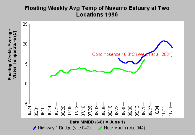
| Caption: The chart shows the floating weekly average water temperature in Celsius (°C) in the Navarro River estuary at Highway 1 Bridge (site 043) and near the mouth (site 044) for the year 1996. Water temperatures patterns in September at Highway 1 may indicate closing of the estuary and meromixis. The latter is a phenomenon where a salt wedge forms on the bottom of the lagoon after a bar has formed. This salt wedge sinks because it is heavier than freshwater and can trap heat, raising water temperatures and diminishing the carrying capacity for salmonids. Welsh et al. (2001) found that coho are not likely to persist where maximum floating weekly average temperature (MWAT) exceeds 16.8°C. See Info Links for more information. Data come from the Mendocino County Water Agency (MCWA). | |
 |
To learn more about this topic click Info Links .
To view additional information (data source, aquisition date etc.) about this page, click Metadata .
To view the table with the chart's data, click Chart Table web page.
To download the table with the chart's data, click estxtab.db (size 36,864 bytes) .
To view the table with the chart's source data, click Source Table web page.
To download the table with the chart's source data, click temperature_proxy.dbf (size 80 bytes)
| www.krisweb.com |