
| Area | Mainstem |
| Topic | Flow: Navarro River - Daily Average, 1993-2001 |
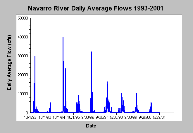
| Caption: This chart displays daily average flows (cfs) for the Navarro River near Navarro, CA (USGS gage # 11468000) between water years 1993 and 2001. There were two large storm events in 1995 with flows in January topping 40,000 cfs and a second March flood peak of 23,300 cfs. The regionally significant January 1, 1997 flood attained flows of 32,200 cfs. The 1998 water year was very wet due to El Nińo but only attained maximum flows of 16,300 cfs. Dry water years included 1994 and 2001. Data are from the US Geological Survey. See Info Links for more information. | |
 |
To learn more about this topic click Info Links .
To view additional information (data source, aquisition date etc.) about this page, click Metadata .
To view the table with the chart's data, click Chart Table web page.
To download the table with the chart's data, click flow_navarro_usgs11468000_1993_2001.dbf (size 118,494 bytes) .
To view the table with the chart's source data, click Source Table web page.
To download the table with the chart's source data, click flow_navarro_usgs11468000_1951_2001.dbf (size 670,770 bytes)
| www.krisweb.com |