
| Area | Mainstem |
| Topic | Flow: Navarro River - Monthly Average, 1951-2001 |
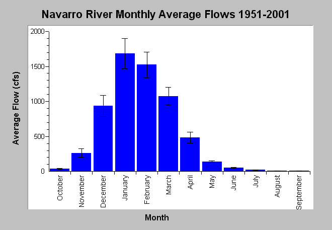
| Caption: This chart displays monthly average flows (cfs) in the Navarro River near Navarro, CA for the years 1951-2001. Storm flow peaks generally occur during winter months and are caused by precipitation runoff. Lower base flows are prevalent between June through October with average monthly stream flow less than 55 cfs between June and October dropping to just over 10 cfs in September. Whiskers bracket one standard error from the mean. Monthly flows are compiled by the US Geological Survey from streamflow measurements gathered at USGS gage #11468000 from water years 1951 and 2001. See Info Links for more information. | |
 |
To learn more about this topic click Info Links .
To view additional information (data source, aquisition date etc.) about this page, click Metadata .
To view the table with the chart's data, click Chart Table web page.
To download the table with the chart's data, click flow_navarro_usgs11468000_monthly_ave_1951_2001.db (size 4,096 bytes) .
To view the table with the chart's source data, click Source Table web page.
To download the table with the chart's source data, click flow_navarro_usgs11468000_monthly_1951_2001.dbf (size 28,346 bytes)
| www.krisweb.com |