
| Area | Mainstem |
| Topic | Habitat: Surveyed Stream Reach Length Mainstem Navarro Sub-basin 1996 |
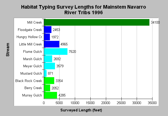
| Caption: The chart shows the total length in feet of California Department of Fish and Game Habitat Typing surveys for the mainstem Navarro River sub-basin reaches in 1996. Mill Creek had the longest survey length with over 6.4 miles surveyed (34,000 feet), but only 871 feet of Mustard Gulch was surveyed. Extremely short surveys may convey a less accurate picture of habitat conditions than longer surveys. Stream orders of tributaries using the Strahler method were determined using 1:24000 USGS Topo maps and are color coded above with dark green = 4th order, dark blue = 3rd order, light blue = 2nd order, light green = 1st order. The survey lengths of lower order streams are usually smaller because of shorter stream length overall. See Info Links for more information. | |
 |
To learn more about this topic click Info Links .
To view additional information (data source, aquisition date etc.) about this page, click Metadata .
To view the table with the chart's data, click Chart Table web page.
To download the table with the chart's data, click hab_mstem_reach_dfg.dbf (size 5,884 bytes) .
To view the table with the chart's source data, click Source Table web page.
To download the table with the chart's source data, click hab_nav_dfg.db (size 18,432 bytes)
| www.krisweb.com |