
| Area | Mainstem |
| Topic | Land Cover: USFS Veg Size for Hendy Woods 1994 |
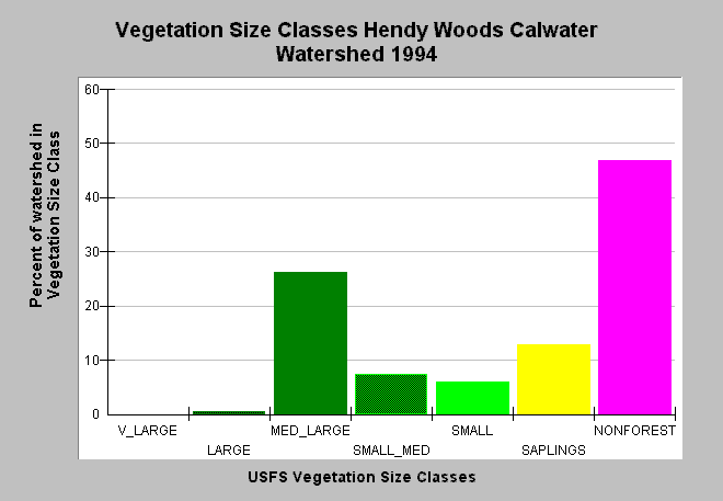
| Caption: This bar chart shows vegetation size classes in the Hendy Woods Calwater Planning Watershed, derived from a 1994 Landsat image by the U.S. Forest Service. While this Calwater has the state park, it is also about half in agriculture on its east side of the Anderson Valley below Philo. This planning watershed had 27% of vegetation in medium-large and greater trees, 26% in small-medium and smaller trees and 47% in non-forest. The vegetation classification is accurate at a one hectare scale and is suitable for stand classification. Click on Map to see spatial data. Click on Info Links for more information. Vegetation is classified according to diameter at breast height (DBH): Very Large = 40-50" DBH, Large = 30-39.9" DBH, Medium/Large = 20-29.9" DBH, Small/Medium = 12-19.9" DBH, Small = 5-11.9" DBH, Saplings = 1-4.9" DBH, Non-Forest = No trees, shrubs, grass, bare soil. | |
 |
To learn more about this topic click Info Links .
To view additional information (data source, aquisition date etc.) about this page, click Metadata .
To view the table with the chart's data, click Chart Table web page.
To download the table with the chart's data, click veg_usfs_nav.dbf (size 5,111 bytes) .
To view the table with the chart's source data, click Source Table web page.
To download the table with the chart's source data, click veg_usfs_nav_source.dbf (size 6,574 bytes)
| www.krisweb.com |