
| Area | Mainstem |
| Topic | Land Cover: USFS Veg Size for Middle Navarro River 1994 |
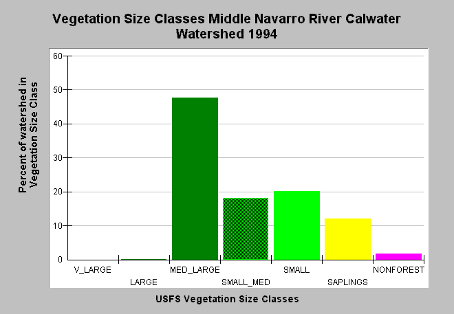
| Caption: This bar chart shows vegetation size classes in the Middle Navarro River Calwater Planning Watershed, derived from a 1994 Landsat image by the U.S. Forest Service. This planning watershed had the most large diameter trees of any other Mainstem Navarro River sub-basin with 48% of vegetation in medium-large (20-30" diameter) and greater trees. Small-medium (12-20") and Small trees (5-12") and saplings (<5 " diameter) made up 51% and 2% of the landscape was Non-forest. The vegetation classification is accurate at a one hectare scale and is suitable for stand classification. Click on Map to see spatial data. Click on Info Links for more information. Sizes are classified according to diameter at breast height (DBH): Very Large = 40-50" DBH, Large = 30-39.9" DBH, Medium/Large = 20-29.9" DBH, Small/Medium = 12-19.9" DBH, Small = 5-11.9" DBH, Saplings = 1-4.9" DBH, Non-Forest = No trees, shrubs, grass, bare soil. | |
 |
To learn more about this topic click Info Links .
To view additional information (data source, aquisition date etc.) about this page, click Metadata .
To view the table with the chart's data, click Chart Table web page.
To download the table with the chart's data, click veg_usfs_nav.dbf (size 5,111 bytes) .
To view the table with the chart's source data, click Source Table web page.
To download the table with the chart's source data, click veg_usfs_nav_source.dbf (size 6,574 bytes)
| www.krisweb.com |