
| Area | Mainstem |
| Topic | Land Cover: USFS Veg Size for Mill Creek 1994 |
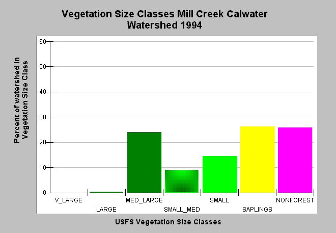
| Caption: This bar chart shows vegetation size classes in the Mill Creek Calwater Planning Watershed, derived from a 1994 Landsat image by the U.S. Forest Service. This planning watershed had 25% of vegetation in medium-large and greater trees, 50% in small-medium and smaller trees. The 26% Non Forest component is caused in part by substantial portions of the Mill Creek Calwater being underlain by Central Belt mťlange terrain which gives rise to grasslands and oak woodlands. Click on Map to see spatial data. Click on Info Links for more information. Vegetation is classified according to diameter at breast height (DBH): Very Large = 40-50" DBH, Large = 30-39.9" DBH, Medium/Large = 20-29.9" DBH, Small/Medium = 12-19.9" DBH, Small = 5-11.9" DBH, Saplings = 1-4.9" DBH, Non-Forest = No trees, shrubs, grass, bare soil. | |
 |
To learn more about this topic click Info Links .
To view additional information (data source, aquisition date etc.) about this page, click Metadata .
To view the table with the chart's data, click Chart Table web page.
To download the table with the chart's data, click veg_usfs_nav.dbf (size 5,111 bytes) .
To view the table with the chart's source data, click Source Table web page.
To download the table with the chart's source data, click veg_usfs_nav_source.dbf (size 6,574 bytes)
| www.krisweb.com |