
| Area | Mainstem |
| Topic | Land Cover: USFS Veg Size in Riparian for Hendy Woods 1994 |
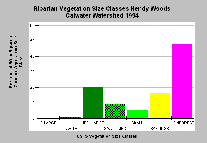
| Caption: This bar chart shows riparian vegetation size classes for the Hendy Woods Calwater Planning Watershed, derived from a 1994 Landsat image by the U.S. Forest Service. Riparian vegetation is defined here as 90 meters (292.5 feet) on either side of the channel. This planning watershed had 21% of the riparian in medium-large and greater trees, 31% in small-medium and smaller trees and 48% in non-forest. The high Non-Forest component indicates both natural grasslands and agricultural areas border streams. The vegetation classification is accurate at a one hectare scale. Click on Map to see spatial data. Vegetation is classified according to diameter at breast height (DBH): Giant = >50" DBH, V Large = 40-50" DBH, Large = 30-39.9" DBH, Medium/Large = 20-29.9" DBH, Small/Medium = 12-19.9" DBH, Small = 5-11.9" DBH, Non-Forest = No trees, shrubs, grass, bare soil. See Info Links for more information. | |
 |
To learn more about this topic click Info Links .
To view additional information (data source, aquisition date etc.) about this page, click Metadata .
To view the table with the chart's data, click Chart Table web page.
To download the table with the chart's data, click veg_usfs_rip_nav.dbf (size 4,712 bytes) .
To view the table with the chart's source data, click Source Table web page.
To download the table with the chart's source data, click veg_usfs_rip_nav_source.dbf (size 6,118 bytes)
| www.krisweb.com |