
| Area | Mainstem |
| Topic | Sediment: Turbidity on Navarro River at Myers Property 1996-00 |
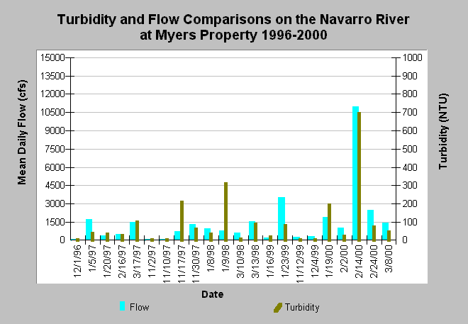
| Caption: The right y-axis of this chart shows turbidity for the Navarro River near Dan Myers' property (site MN046) and the left axis shows stream flow at the USGS gage on the mainstem Navarro River. Turbidity samples collected near peak flow events. Turbidity is in Nephelometric Turbidity Units (NTU), and flows are mean daily, measured in cubic feet per second (CFS).Values higher than 25 ntu may hamper steelhead juvenile growth (Sigler et al., 1984). Data were collected by volunteers and provided by Mendocino County Water Agency. See Info Links for more information. | |
 |
To learn more about this topic click Info Links .
To view additional information (data source, aquisition date etc.) about this page, click Metadata .
To view the table with the chart's data, click Chart Table web page.
To download the table with the chart's data, click nav_turb_mn046.dbf (size 1,020 bytes) .
To view the table with the chart's source data, click Source Table web page.
To download the table with the chart's source data, click nav_turb_mcwa.dbf (size 1,926 bytes)
| www.krisweb.com |