
| Area | Rancheria Creek |
| Topic | Habitat: Canopy by Type Rancheria Creek Sub-basin 1996 |
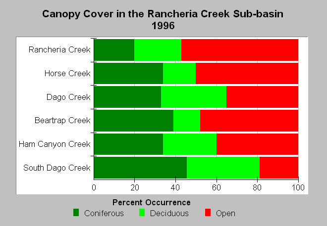
| Caption: The chart shows canopy closure from habitat typing surveys in the Rancheria Creek Sub-basin in 1996. Streams are sorted by Strahler order, with larger streams at the top. All streams surveyed showed significant amounts of open canopy, and the percentage of streambank covered by coniferous canopy was poor for all streams. None of the streams surveyed exceeded 50%. South Fork Dago Creek had the largest percentage of coniferous canopy with 41%. CDFG stream survey reports state, "In general, revegetation projects are considered when canopy density is less than 80%." Data were provided by CDFG . See Info Links for more information. | |
 |
To learn more about this topic click Info Links .
To view additional information (data source, aquisition date etc.) about this page, click Metadata .
To view the table with the chart's data, click Chart Table web page.
To download the table with the chart's data, click hab_ranch_canopy_dfg.dbf (size 4,114 bytes) .
To view the table with the chart's source data, click Source Table web page.
To download the table with the chart's source data, click hab_nav_dfg.db (size 18,432 bytes)
| www.krisweb.com |