
|

|
| Background | Hypotheses | Bibliography | Maps | Home |
|
|
|
| Background | Hypotheses | Bibliography | Maps | Home |
KRIS Web Background Pages: Vegetation Types
![]()
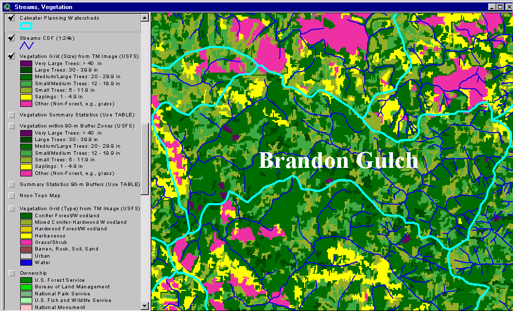
The 1994 Landsat imagery processed by the U.S. Forest Service Southwest Region Remote Sensing Lab is available in the KRIS Noyo Map project. It allows a quick review of seral stages in various CalWater planning units. The data from the USFS have been filtered for tree size not type and tree size is used as a surrogate for seral stage. Data from the California Department of Forestry on timber harvests is also incorporated into KRIS Noyo Maps and can be used in conjunction with the USFS vegetation classification to explore watershed disturbance. Watersheds with lower disturbance levels are more likely to have a diverse assemblage of salmonid species (Reeves et al., 1993).
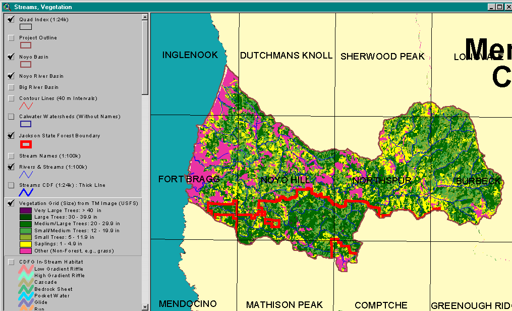 |
This image, from the KRIS Noyo Map project USFS vegetation coverage for the entire Noyo River Basin, is displayed with a USGS topo grid to show general location. Much of the Noyo landscape is characterized as early seral stands with Non-Forest (grass/shrubs/bare soil) and Saplings (trees 2-4.9" diameter). The signature of Large trees (30-39.9") and Medium/Large trees (20-29.9") is more prevalent in the South Fork watershed and parts of the North Fork and Upper Noyo basins. |
The vegetation data can also be reviewed as summary charts in the KRIS Noyo database:
|
|
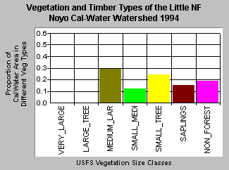
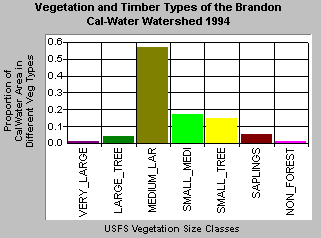
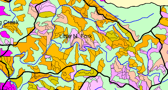
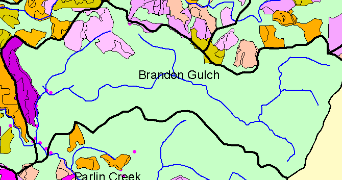
| The Little North Fork Noyo CalWater planning watershed had 30% Medium/Large trees according to the USFS vegetation classification based on 1994 Landsat imagery. The next most abundant categories were Small Trees (24%), Non-Forest (19%), Saplings (15%) and Small/Medium trees making up the balance. See map view of the Little North Fork Vegetation below. | The Brandon Gulch CalWater unit is in Jackson State Demonstration Forest and actually encompasses the North Fork South Fork Noyo River. The USFS stand classification data indicate that Medium/Large trees (20-29.9" diameter) comprised over half of this CalWater planning unit. Trees larger than 30 inches in diameter made of 5% of the landscape. Early seral components are lower than in the Little North Fork Noyo basin. |
 82 KB |
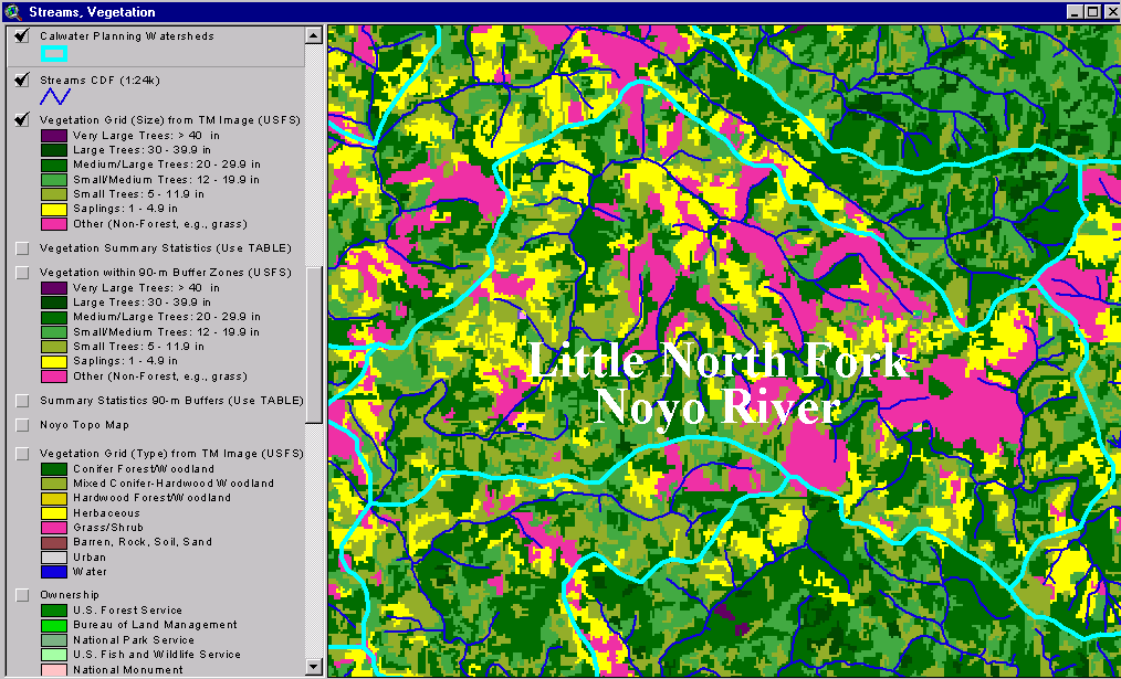
This image from the KRIS Noyo Map project shows the 1994 USFS vegetation classification for the Little North Fork Noyo River CalWater. Large, contiguous areas of Non-Forest stand types are disbursed throughout the watershed. Saplings, Small trees, Small/Medium trees and Medium trees are all interspersed in patches throughout the watershed. Areas adjacent to streams may not show riparian buffers in this coverage because it characterizes vegetation stands at a one hectare scale and riparian zones may not be sufficiently wide to influence classification. |
 78 KB |
This is an image taken from the KRIS Noyo Map ArcView project showing the vegetation types derived from a 1994 Landsat image of the Brandon Gulch Calwater unit (NF South Fork Noyo basin). Very Large trees (>40" diameter) and Large Trees (30-39.9") comprised 5% of the watershed and consist of disbursed patches. Medium trees (20-29.9") are well represented throughout the watershed. Non-Forest (shrubs, grass, bare soil) and Saplings (2-4.9" diameter trees) are found only in the western portion of the basin. |
26 KB |
This KRIS Map image shows California Department of Forestry data for the permitted timber harvests between 1985 and 1993 in the Little North Fork Noyo CalWater planning watershed. The extent of timber harvest is reflected in early seral stage conditions in 1994, as the USFS vegetation stand map (above) shows. |
15 KB |
The KRIS Map image above shows California Department of Forestry data for the permitted timber harvests in Brandon Gulch. The purple and pink polygons in the western portion of the basin were permitted timber harvests in 1993 and 1990, respectively. |
![]()
References
Reeves, G.H., F.H. Everest and J.R. Sedell. 1993 . Diversity of Juvenile Anadromous Salmonid Assemblages in Coastal Oregon Basins with Different Levels of Timber Harvest. Transactions of the American Fisheries Society. Vol 122, No. 3. May 1993.
Schwind, B. 1999. USFS Thematic Mapper Landsat Vegetation Coverage Background Information. USDA Forest Service. Pacific Southwest Region Remote Sensing Lab. Sacramento, CA.
Warbington, R., B. Schwind, C. Curlis and S. Daniel. 1998. Creating a Consistent and Standardized Vegetation Database for Northwest Forest Plan Monitoring in California. USDA Forest Service. Pacific Southwest Region Remote Sensing Lab. Sacramento, CA.
![]()
| www.krisweb.com |