
| Area | Basin-wide/Regional |
| Topic | Sediment: Road Stream Crossing Density for Russian River Sub-basins |
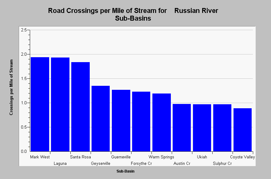
| Caption: This chart shows a summary of the densities of road crossings per stream mile for all KRIS Russian River sub-basins. Most sub-basins contain a stream crossing density near or greater than one road crossing per mile of stream. Higher densities are typically associated with highly urbanized areas. Road and stream data originates from 1:24,000 scale topographic maps and under represent road densities, especially in urban and timber harvest areas. Roads densities are calculated by KRIS IFR staff in Arc Info. See Map to review spatial data related to basin wide roads. See InfoLinks for more information. | |
 |
To learn more about this topic click Info Links .
To view additional information (data source, aquisition date etc.) about this page, click Metadata .
To view the table with the chart's data, click Chart Table web page.
To download the table with the chart's data, click roads_russian_subbasins_24k.dbf (size 1,176 bytes) .
To view the table with the chart's source data, click Source Table web page.
To download the table with the chart's source data, click roads_russian_calwaters_24k.dbf (size 27,124 bytes)
| www.krisweb.com |