
| Area | Basin-wide/Regional |
| Topic | Sediment: Sediment Transport Russian at Guerneville 1965-1986 |
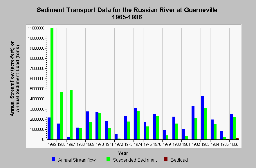
| Caption: This chart shows annual streamflow in acre-feet, suspended sediment load in tons/year, and bedload in tons/year for the Russian River at Guerneville (USGS flow gage #11467000) for water years 1965-1986 missing 1976 and 1977. Bedload was only measured in 1985 and 1986 so the rest of results are derived from models. Sediment data come from Swanson and Associates (1994) and were originally reported by the US Geological. Data from Ritter and Brown (1971) for 1965-1967. The high sediment data were partly as a result of Eel River water influences following the 1964 flood (YR 1965). See InfoLinks for more information. | |
 |
To learn more about this topic click Info Links .
To view additional information (data source, aquisition date etc.) about this page, click Metadata .
To view the table with the chart's data, click Chart Table web page.
To download the table with the chart's data, click sed_russian_guerneville_suspended_1965_1986.dbf (size 902 bytes) .
| www.krisweb.com |