
| Area | Basin-wide/Regional |
| Topic | Stream Channel: Cross-Section - Russian River rm62.0 |
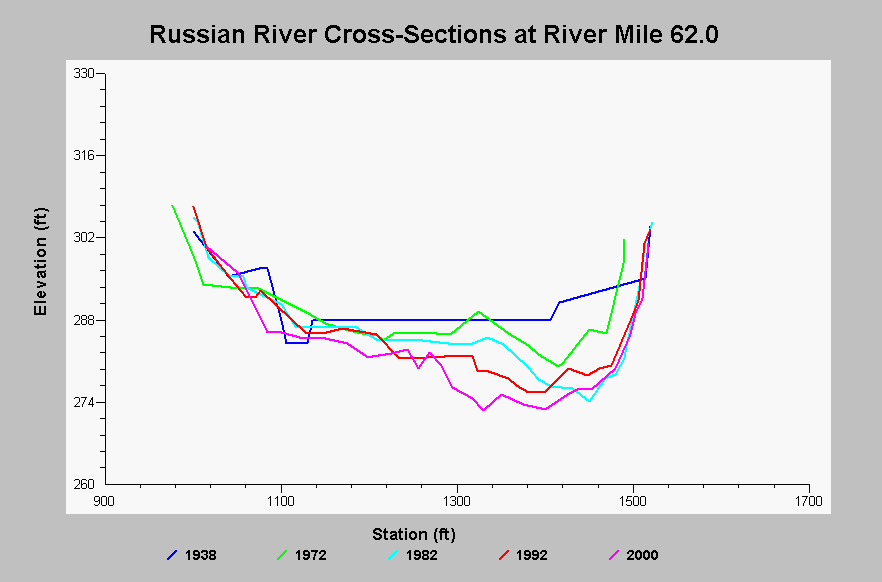
| Caption: This chart shows cross-section surveys on the Russian River at river mile 62.0, located in Alexander Valley at the Cloverdale Bridge. Since 1938, the channel has progressively down cut and widened. The thalweg elevation change between 1937 and 2000 is -12.4 feet. Data come from the Sonoma County Water Agency and were collected as part of the Russian River Aggregate Resource Management monitoring. Cross-section data pre-1991 were digitized from digitized from SCWA cross-sectional blue prints by NW Hydraulics. See InfoLinks for more information. | |
 |
To learn more about this topic click Info Links .
To view additional information (data source, aquisition date etc.) about this page, click Metadata .
To view the table with the chart's data, click Chart Table web page.
To download the table with the chart's data, click xs_rm620_rr_arm_1938_2000.dbf (size 25,561 bytes) .
| www.krisweb.com |